Barge elevation
Barge (Piedmont, Provincia di Cuneo), Italy elevation is 374 meters and Barge elevation in feet is 1227 ft above sea level [src 1]. Barge is a seat of a third-order administrative division (feature code) with elevation that is 52 meters (171 ft) bigger than average city elevation in Italy.
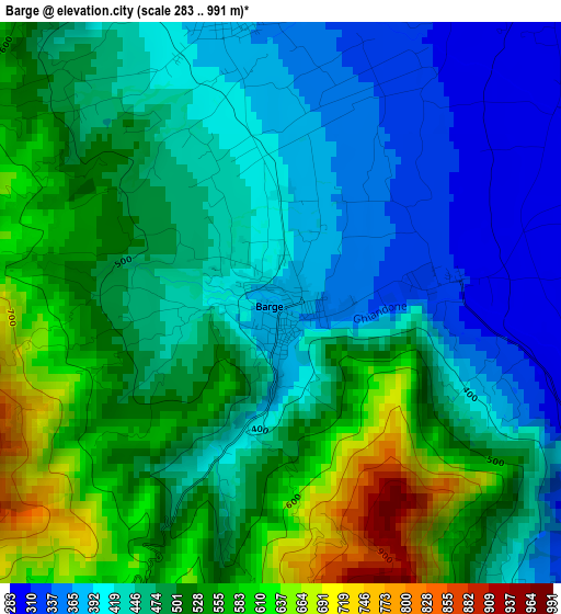
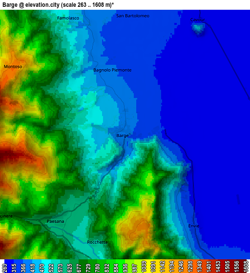
Below is the Elevation map of Barge, which displays elevation range with different colors. Scale of the first map is from 283 to 991 m (928 to 3251 ft) with average elevation of 478.8 meters (=1571 ft) [note 1]
These maps also provides idea of topography and contour of this city, they are displayed at different zoom levels. More info about maps, scale and edge coordinates you can find below images.
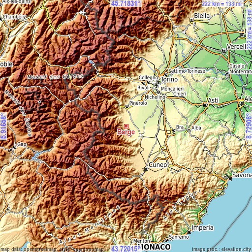
| \ | Map #1 | Map #2 | Topo.Map |
| Scale [m] | 283..991 m | 263..1608 m | × |
| Scale [ft] | 928..3251 ft | 863..5276 ft | × |
| Average | 478.8 m = 1571 ft | 566.2 m = 1858 ft | × |
| Width | 6.94 km = 4.3 mi | 13.89 km = 8.6 mi | 222.2 km = 138.1 mi |
| Height | 6.94 km = 4.3 mi | 13.89 km = 8.6 mi | 222.2 km = 138.1 mi |
| ↑Max Latitude | 44.759073° | 44.790269° | 45.71831° |
| Latitude at center | 44.72786° | 44.72786° | 44.72786° |
| ↓Min Latitude | 44.69663° | 44.665384° | 43.72015° |
| ← Min Longitude | 7.278885° | 7.234939° | 5.91658° |
| Longitude center | 7.32283° | 7.32283° | 7.32283° |
| →Max Longitude | 7.366775° | 7.410721° | 8.72908° |
Nearby cities:
Cities around Barge sort by population:
• Cavour elevation 307 m
8.3 km,  29°
29°
• Bagnolo Piemonte 373 m
3.7 km,  348°
348°
• Bricherasio 389 m
10.7 km, 351°
• Bibiana 415 m
8.4 km,  340°
340°
• Revello 353 m
9.7 km,  146°
146°
• Paesana 608 m
6.2 km,  216°
216°
• Sanfront 479 m
9 km,  180°
180°
• Luserna 499 m
10.7 km,  325°
325°
• Envie 332 m
6.4 km,  142°
142°
• Rifreddo 440 m
8.8 km,  167°
167°
• Campiglione 365 m
8.3 km,  0°
0°
• Lusernetta 502 m
10.3 km,  324°
324°
Multilingual:
 En español:
Barge elevación 374 m.
 En France:
Barge élévation 374 m.


Sources and notes:
- [note 1] Map square and city borders are not equal. Map elevation data is calculated only from area inside that square.
- [src 1] Elevation data from geonames database provided with same terms of usage.
- [src 2] The elevation map of Barge is generated using elevation data from NASA's 3 arcsec (90m) resolution SRTM data.
- [src 3] Base (background) map © OpenStreetMap contributors tiles are generated by Geofabrik and OpenTopoMap.
Copyright & License:
This Barge Elevation Map is licensed under CC BY-SA. You may reuse any part from this page, if you give a proper credit by linking to this URL:
 More info on terms of use page.