Rifreddo elevation
Rifreddo (Piedmont, Provincia di Cuneo), Italy elevation is 440 meters and Rifreddo elevation in feet is 1444 ft above sea level [src 1]. Rifreddo is a seat of a third-order administrative division (feature code) with elevation that is 118 meters (387 ft) bigger than average city elevation in Italy.
Below is the Elevation map of Rifreddo, which displays elevation range with different colors. Scale of the first map is from 293 to 1290 m (961 to 4232 ft) with average elevation of 585.4 meters (=1921 ft) [note 1]
These maps also provides idea of topography and contour of this city, they are displayed at different zoom levels. More info about maps, scale and edge coordinates you can find below images.
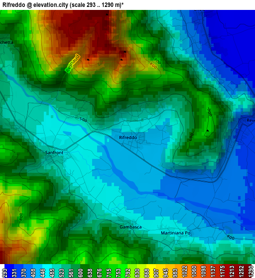
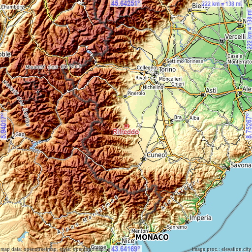
| \ | Map #1 | Topo.Map |
| Scale [m] | 293..1290 m | × |
| Scale [ft] | 961..4232 ft | × |
| Average | 585.4 m = 1921 ft | × |
| Width | 6.95 km = 4.3 mi | 222.5 km = 138.3 mi |
| Height | 6.95 km = 4.3 mi | 222.5 km = 138.3 mi |
| ↑Max Latitude | 44.681984° | 45.64251° |
| Latitude at center | 44.65073° | 44.65073° |
| ↓Min Latitude | 44.619459° | 43.64169° |
| ← Min Longitude | 7.302475° | 5.94017° |
| Longitude center | 7.34642° | 7.34642° |
| →Max Longitude | 7.390365° | 8.75267° |
Nearby cities:
Cities around Rifreddo sort by population:
• Barge elevation 374 m
8.8 km,  347°
347°
• Revello 353 m
3.5 km,  83°
83°
• Paesana 608 m
6.7 km,  302°
302°
• Sanfront 479 m
1.9 km,  257°
257°
• Brossasco 587 m
9.3 km,  171°
171°
• Martiniana Po 459 m
2.9 km,  153°
153°
• Envie 332 m
4 km,  30°
30°
• Pagno 374 m
7.6 km,  124°
124°
• Gambasca 490 m
2.4 km,  179°
179°
• Castellar 354 m
7.9 km,  114°
114°
• Brondello 463 m
7.3 km,  139°
139°
• Isasca 667 m
7.5 km,  158°
158°
Multilingual:
 En español:
Rifreddo elevación 440 m.
 En France:
Rifreddo élévation 440 m.
 Auf Deutsch:
Rifreddo höhe über dem Meeresspiegel ist 440 m.

Sources and notes:
- [note 1] Map square and city borders are not equal. Map elevation data is calculated only from area inside that square.
- [src 1] Elevation data from geonames database provided with same terms of usage.
- [src 2] The elevation map of Rifreddo is generated using elevation data from NASA's 3 arcsec (90m) resolution SRTM data.
- [src 3] Base (background) map © OpenStreetMap contributors tiles are generated by Geofabrik and OpenTopoMap.
Copyright & License:
This Rifreddo Elevation Map is licensed under CC BY-SA. You may reuse any part from this page, if you give a proper credit by linking to this URL:
 More info on terms of use page.