Bevagna elevation
Bevagna (Umbria, Provincia di Perugia), Italy elevation is 220 meters and Bevagna elevation in feet is 722 ft above sea level [src 1]. Bevagna is a seat of a third-order administrative division (feature code) with elevation that is 102 meters (335 ft) smaller than average city elevation in Italy.
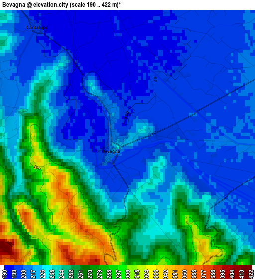
Below is the Elevation map of Bevagna, which displays elevation range with different colors. Scale of the first map is from 190 to 422 m (623 to 1385 ft) with average elevation of 233.7 meters (=767 ft) [note 1]
These maps also provides idea of topography and contour of this city, they are displayed at different zoom levels. More info about maps, scale and edge coordinates you can find below images.
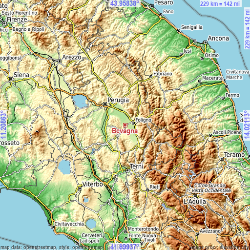
| \ | Map #1 | Topo.Map |
| Scale [m] | 190..422 m | × |
| Scale [ft] | 623..1385 ft | × |
| Average | 233.7 m = 767 ft | × |
| Width | 7.15 km = 4.4 mi | 228.9 km = 142.2 mi |
| Height | 7.15 km = 4.4 mi | 228.9 km = 142.2 mi |
| ↑Max Latitude | 42.969644° | 43.95838° |
| Latitude at center | 42.93748° | 42.93748° |
| ↓Min Latitude | 42.905299° | 41.89937° |
| ← Min Longitude | 12.570935° | 11.20863° |
| Longitude center | 12.61488° | 12.61488° |
| →Max Longitude | 12.658825° | 14.02113° |
Nearby cities:
Cities around Bevagna sort by population:
• Foligno elevation 242 m
7.4 km,  74°
74°
• Trevi 410 m
12.8 km,  121°
121°
• Spello 213 m
7.4 km,  34°
34°
• Giano dell'Umbria 531 m
11.9 km,  194°
194°
• Cannara 193 m
7 km,  337°
337°
• Bastardo 285 m
8.6 km,  211°
211°
• Rivotorto 226 m
11.9 km,  2°
2°
• Montefalco 428 m
5.9 km,  152°
152°
• Capitan Loreto 212 m
9.3 km,  16°
16°
• Passaggio 188 m
12.8 km,  317°
317°
• Bettona 348 m
13.2 km,  308°
308°
• Gualdo Cattaneo 452 m
5.5 km,  239°
239°
Multilingual:
 En español:
Bevagna elevación 220 m.
 En France:
Bevagna élévation 220 m.


Sources and notes:
- [note 1] Map square and city borders are not equal. Map elevation data is calculated only from area inside that square.
- [src 1] Elevation data from geonames database provided with same terms of usage.
- [src 2] The elevation map of Bevagna is generated using elevation data from NASA's 3 arcsec (90m) resolution SRTM data.
- [src 3] Base (background) map © OpenStreetMap contributors tiles are generated by Geofabrik and OpenTopoMap.
Copyright & License:
This Bevagna Elevation Map is licensed under CC BY-SA. You may reuse any part from this page, if you give a proper credit by linking to this URL:
 More info on terms of use page.