Trevi elevation
Trevi (Umbria, Provincia di Perugia), Italy elevation is 410 meters and Trevi elevation in feet is 1345 ft above sea level [src 1]. Trevi is a seat of a third-order administrative division (feature code) with elevation that is 88 meters (289 ft) bigger than average city elevation in Italy.
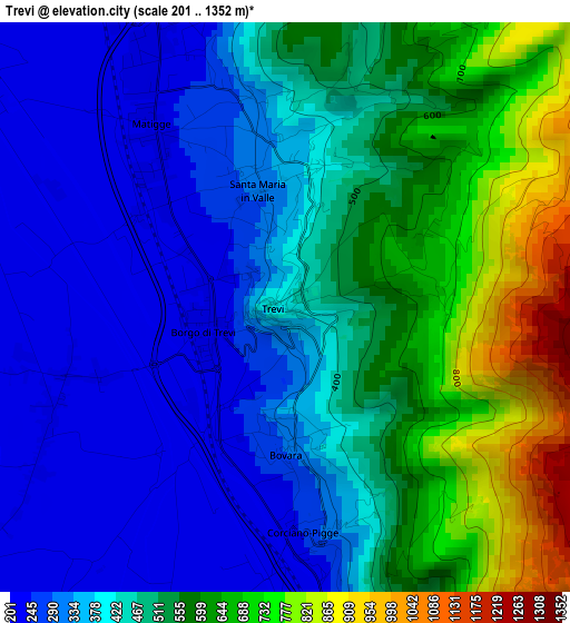
Below is the Elevation map of Trevi, which displays elevation range with different colors. Scale of the first map is from 201 to 1352 m (659 to 4436 ft) with average elevation of 458.2 meters (=1503 ft) [note 1]
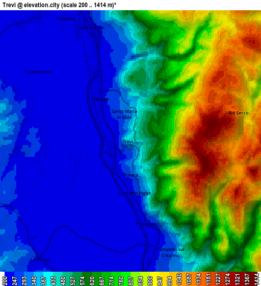
These maps also provides idea of topography and contour of this city, they are displayed at different zoom levels. More info about maps, scale and edge coordinates you can find below images.
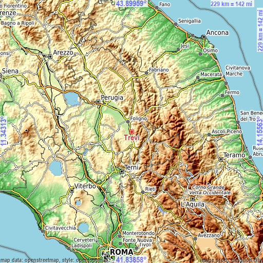
| \ | Map #1 | Map #2 | Topo.Map |
| Scale [m] | 201..1352 m | 200..1414 m | × |
| Scale [ft] | 659..4436 ft | 656..4639 ft | × |
| Average | 458.2 m = 1503 ft | 520.5 m = 1708 ft | × |
| Width | 7.16 km = 4.4 mi | 14.32 km = 8.9 mi | 229.2 km = 142.4 mi |
| Height | 7.16 km = 4.4 mi | 14.32 km = 8.9 mi | 229.2 km = 142.4 mi |
| ↑Max Latitude | 42.909885° | 42.942063° | 43.89959° |
| Latitude at center | 42.87769° | 42.87769° | 42.87769° |
| ↓Min Latitude | 42.845478° | 42.813249° | 41.83858° |
| ← Min Longitude | 12.705435° | 12.661489° | 11.34313° |
| Longitude center | 12.74938° | 12.74938° | 12.74938° |
| →Max Longitude | 12.793325° | 12.837271° | 14.15563° |
Nearby cities:
Cities around Trevi sort by population:
• Foligno elevation 242 m
9.4 km,  336°
336°
• Spoleto 326 m
15.3 km,  183°
183°
• Spello 213 m
14.4 km,  332°
332°
• Giano dell'Umbria 531 m
14.8 km,  250°
250°
• Bevagna 220 m
12.8 km,  301°
301°
• Campello sul Clitunno 231 m
5.9 km,  163°
163°
• San Giacomo 250 m
9.3 km, 178°
• Montefalco 428 m
8.4 km,  280°
280°
• Bruna 239 m
8 km,  218°
218°
• Castel Ritaldi 298 m
8.7 km, 224°
• Cerreto di Spoleto 551 m
15.3 km,  114°
114°
• Sellano 629 m
14.2 km,  85°
85°
Multilingual:
 En español:
Trevi elevación 410 m.
 En France:
Trevi élévation 410 m.


Sources and notes:
- [note 1] Map square and city borders are not equal. Map elevation data is calculated only from area inside that square.
- [src 1] Elevation data from geonames database provided with same terms of usage.
- [src 2] The elevation map of Trevi is generated using elevation data from NASA's 3 arcsec (90m) resolution SRTM data.
- [src 3] Base (background) map © OpenStreetMap contributors tiles are generated by Geofabrik and OpenTopoMap.
Copyright & License:
This Trevi Elevation Map is licensed under CC BY-SA. You may reuse any part from this page, if you give a proper credit by linking to this URL:
 More info on terms of use page.