Sellano elevation
Sellano (Umbria, Provincia di Perugia), Italy elevation is 629 meters and Sellano elevation in feet is 2064 ft above sea level [src 1]. Sellano is a seat of a third-order administrative division (feature code) with elevation that is 307 meters (1007 ft) bigger than average city elevation in Italy.
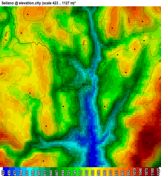
Below is the Elevation map of Sellano, which displays elevation range with different colors. Scale of the first map is from 423 to 1127 m (1388 to 3698 ft) with average elevation of 777.5 meters (=2551 ft) [note 1]
These maps also provides idea of topography and contour of this city, they are displayed at different zoom levels. More info about maps, scale and edge coordinates you can find below images.
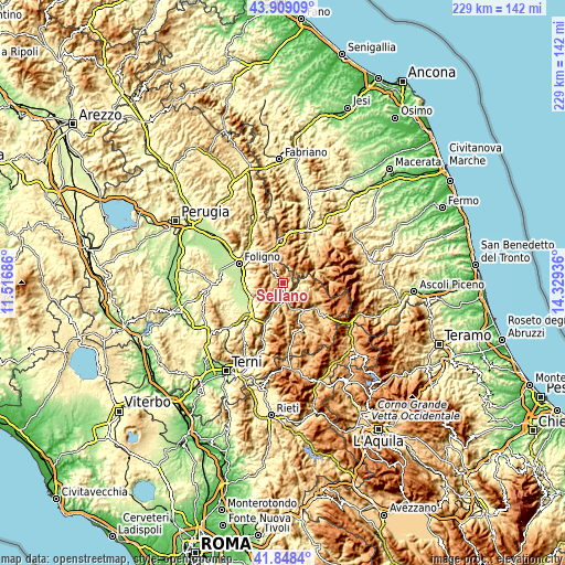
| \ | Map #1 | Topo.Map |
| Scale [m] | 423..1127 m | × |
| Scale [ft] | 1388..3698 ft | × |
| Average | 777.5 m = 2551 ft | × |
| Width | 7.16 km = 4.4 mi | 229.1 km = 142.4 mi |
| Height | 7.16 km = 4.4 mi | 229.1 km = 142.4 mi |
| ↑Max Latitude | 42.91954° | 43.90909° |
| Latitude at center | 42.88735° | 42.88735° |
| ↓Min Latitude | 42.855143° | 41.8484° |
| ← Min Longitude | 12.879165° | 11.51686° |
| Longitude center | 12.92311° | 12.92311° |
| →Max Longitude | 12.967055° | 14.32936° |
Nearby cities:
Cities around Sellano sort by population:
• Trevi elevation 410 m
14.2 km,  265°
265°
• Norcia 604 m
17.7 km,  127°
127°
• Campello sul Clitunno 231 m
14.2 km,  241°
241°
• San Giacomo 250 m
17.4 km,  233°
233°
• Visso 603 m
13.8 km,  68°
68°
• Cerreto di Spoleto 551 m
7.3 km,  181°
181°
• Preci 525 m
9.3 km,  94°
94°
• Sant'Anatolia di Narco 337 m
18.6 km,  202°
202°
• Castelsantangelo sul Nera 735 m
18.9 km, 87°
• Meggiano 451 m
15.5 km, 198°
• Pie' del Sasso 672 m
13.4 km,  27°
27°
• Fluminata 724 m
18.3 km, 69°
Multilingual:
 En español:
Sellano elevación 629 m.
 En France:
Sellano élévation 629 m.


Sources and notes:
- [note 1] Map square and city borders are not equal. Map elevation data is calculated only from area inside that square.
- [src 1] Elevation data from geonames database provided with same terms of usage.
- [src 2] The elevation map of Sellano is generated using elevation data from NASA's 3 arcsec (90m) resolution SRTM data.
- [src 3] Base (background) map © OpenStreetMap contributors tiles are generated by Geofabrik and OpenTopoMap.
Copyright & License:
This Sellano Elevation Map is licensed under CC BY-SA. You may reuse any part from this page, if you give a proper credit by linking to this URL:
 More info on terms of use page.