Bibbona elevation
Bibbona (Tuscany, Provincia di Livorno), Italy elevation is 48 meters and Bibbona elevation in feet is 157 ft above sea level [src 1]. Bibbona is a seat of a third-order administrative division (feature code) with elevation that is 274 meters (899 ft) smaller than average city elevation in Italy.
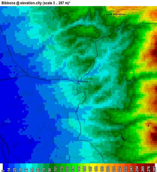
Below is the Elevation map of Bibbona, which displays elevation range with different colors. Scale of the first map is from 3 to 287 m (10 to 942 ft) with average elevation of 71.8 meters (=236 ft) [note 1]
These maps also provides idea of topography and contour of this city, they are displayed at different zoom levels. More info about maps, scale and edge coordinates you can find below images.
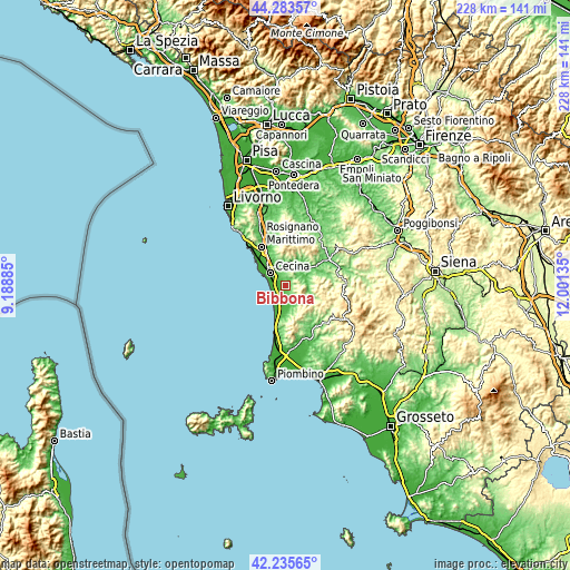
| \ | Map #1 | Topo.Map |
| Scale [m] | 3..287 m | × |
| Scale [ft] | 10..942 ft | × |
| Average | 71.8 m = 236 ft | × |
| Width | 7.12 km = 4.4 mi | 227.7 km = 141.5 mi |
| Height | 7.12 km = 4.4 mi | 227.7 km = 141.5 mi |
| ↑Max Latitude | 43.300211° | 44.28357° |
| Latitude at center | 43.26822° | 43.26822° |
| ↓Min Latitude | 43.236213° | 42.23565° |
| ← Min Longitude | 10.551155° | 9.18885° |
| Longitude center | 10.5951° | 10.5951° |
| →Max Longitude | 10.639045° | 12.00135° |
Nearby cities:
Cities around Bibbona sort by population:
• Cecina elevation 8 m
7.6 km,  303°
303°
• Donoratico 23 m
11.2 km,  191°
191°
• Vada 1 m
14.7 km,  309°
309°
• S.P. in Palazzi 8 m
9.6 km, 313°
• Castagneto Carducci 202 m
12 km,  173°
173°
• La California 9 m
4.2 km,  271°
271°
• Guardistallo 251 m
5.8 km,  28°
28°
• Montescudaio 224 m
6.9 km,  21°
21°
• Riparbella 209 m
10.7 km,  1°
1°
• Casale Marittimo 205 m
3.7 km, 28°
• Monteverdi Marittimo 334 m
13.8 km,  136°
136°
• Sassetta 344 m
16 km, 165°
Multilingual:
 En español:
Bibbona elevación 48 m.
 En France:
Bibbona élévation 48 m.


Sources and notes:
- [note 1] Map square and city borders are not equal. Map elevation data is calculated only from area inside that square.
- [src 1] Elevation data from geonames database provided with same terms of usage.
- [src 2] The elevation map of Bibbona is generated using elevation data from NASA's 3 arcsec (90m) resolution SRTM data.
- [src 3] Base (background) map © OpenStreetMap contributors tiles are generated by Geofabrik and OpenTopoMap.
Copyright & License:
This Bibbona Elevation Map is licensed under CC BY-SA. You may reuse any part from this page, if you give a proper credit by linking to this URL:
 More info on terms of use page.