Guardistallo elevation
Guardistallo (Tuscany, Province of Pisa), Italy elevation is 251 meters and Guardistallo elevation in feet is 823 ft above sea level [src 1]. Guardistallo is a seat of a third-order administrative division (feature code) with elevation that is 71 meters (233 ft) smaller than average city elevation in Italy.
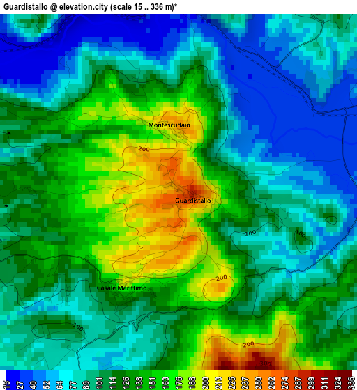
Below is the Elevation map of Guardistallo, which displays elevation range with different colors. Scale of the first map is from 15 to 336 m (49 to 1102 ft) with average elevation of 114 meters (=374 ft) [note 1]
These maps also provides idea of topography and contour of this city, they are displayed at different zoom levels. More info about maps, scale and edge coordinates you can find below images.
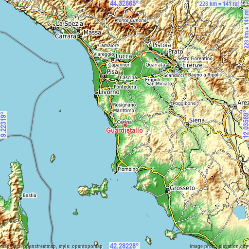
| \ | Map #1 | Topo.Map |
| Scale [m] | 15..336 m | × |
| Scale [ft] | 49..1102 ft | × |
| Average | 114 m = 374 ft | × |
| Width | 7.11 km = 4.4 mi | 227.5 km = 141.4 mi |
| Height | 7.11 km = 4.4 mi | 227.5 km = 141.4 mi |
| ↑Max Latitude | 43.346046° | 44.32865° |
| Latitude at center | 43.31408° | 43.31408° |
| ↓Min Latitude | 43.282097° | 42.28228° |
| ← Min Longitude | 10.585495° | 9.22319° |
| Longitude center | 10.62944° | 10.62944° |
| →Max Longitude | 10.673385° | 12.03569° |
Nearby cities:
Cities around Guardistallo sort by population:
• Cecina elevation 8 m
9.1 km,  264°
264°
• Vada 1 m
14.7 km,  286°
286°
• S.P. in Palazzi 8 m
9.9 km,  278°
278°
• Rosignano Marittimo 147 m
16.4 km,  309°
309°
• Saline 71 m
15.8 km,  70°
70°
• Bibbona 48 m
5.8 km,  208°
208°
• La California 9 m
8.6 km,  234°
234°
• Montescudaio 224 m
1.4 km,  348°
348°
• Riparbella 209 m
6.1 km,  335°
335°
• Castellina Marittima 366 m
11.8 km, 338°
• Casale Marittimo 205 m
2.1 km, 209°
• Montecatini Val di Cecina 397 m
13 km,  48°
48°
Multilingual:
 En español:
Guardistallo elevación 251 m.
 En France:
Guardistallo élévation 251 m.
 Auf Deutsch:
Guardistallo höhe über dem Meeresspiegel ist 251 m.

Sources and notes:
- [note 1] Map square and city borders are not equal. Map elevation data is calculated only from area inside that square.
- [src 1] Elevation data from geonames database provided with same terms of usage.
- [src 2] The elevation map of Guardistallo is generated using elevation data from NASA's 3 arcsec (90m) resolution SRTM data.
- [src 3] Base (background) map © OpenStreetMap contributors tiles are generated by Geofabrik and OpenTopoMap.
Copyright & License:
This Guardistallo Elevation Map is licensed under CC BY-SA. You may reuse any part from this page, if you give a proper credit by linking to this URL:
 More info on terms of use page.