Sassetta elevation
Sassetta (Tuscany, Provincia di Livorno), Italy elevation is 344 meters and Sassetta elevation in feet is 1129 ft above sea level [src 1]. Sassetta is a seat of a third-order administrative division (feature code) with elevation that is 22 meters (72 ft) bigger than average city elevation in Italy.
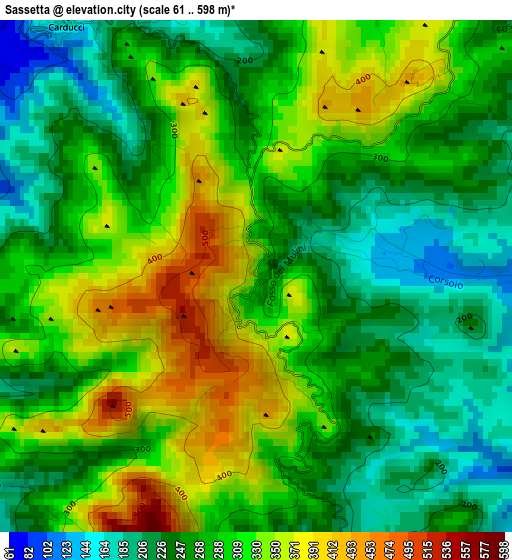
Below is the Elevation map of Sassetta, which displays elevation range with different colors. Scale of the first map is from 61 to 598 m (200 to 1962 ft) with average elevation of 284.8 meters (=934 ft) [note 1]
These maps also provides idea of topography and contour of this city, they are displayed at different zoom levels. More info about maps, scale and edge coordinates you can find below images.
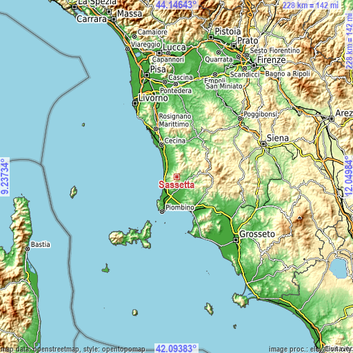
| \ | Map #1 | Topo.Map |
| Scale [m] | 61..598 m | × |
| Scale [ft] | 200..1962 ft | × |
| Average | 284.8 m = 934 ft | × |
| Width | 7.13 km = 4.4 mi | 228.2 km = 141.8 mi |
| Height | 7.13 km = 4.4 mi | 228.2 km = 141.8 mi |
| ↑Max Latitude | 43.160804° | 44.14643° |
| Latitude at center | 43.12874° | 43.12874° |
| ↓Min Latitude | 43.096659° | 42.09383° |
| ← Min Longitude | 10.599645° | 9.23734° |
| Longitude center | 10.64359° | 10.64359° |
| →Max Longitude | 10.687535° | 12.04984° |
Nearby cities:
Cities around Sassetta sort by population:
• Venturina elevation 14 m
11.6 km,  197°
197°
• San Vincenzo 7 m
9.2 km,  242°
242°
• Donoratico 23 m
7.6 km,  306°
306°
• Suvereto 70 m
6.4 km,  154°
154°
• Vignale Riotorto 35 m
16.9 km,  168°
168°
• Campiglia Marittima 213 m
8 km, 197°
• Castagneto Carducci 202 m
4.4 km,  323°
323°
• Bibbona 48 m
16 km,  345°
345°
• La California 9 m
17.6 km,  332°
332°
• Monterotondo Marittimo 536 m
17.3 km,  83°
83°
• Casale Marittimo 205 m
18.9 km, 353°
• Monteverdi Marittimo 334 m
7.7 km,  45°
45°
Multilingual:
 En español:
Sassetta elevación 344 m.
 En France:
Sassetta élévation 344 m.
 Auf Deutsch:
Sassetta höhe über dem Meeresspiegel ist 344 m.

Sources and notes:
- [note 1] Map square and city borders are not equal. Map elevation data is calculated only from area inside that square.
- [src 1] Elevation data from geonames database provided with same terms of usage.
- [src 2] The elevation map of Sassetta is generated using elevation data from NASA's 3 arcsec (90m) resolution SRTM data.
- [src 3] Base (background) map © OpenStreetMap contributors tiles are generated by Geofabrik and OpenTopoMap.
Copyright & License:
This Sassetta Elevation Map is licensed under CC BY-SA. You may reuse any part from this page, if you give a proper credit by linking to this URL:
 More info on terms of use page.