Cadine elevation
Cadine (Trentino-Alto Adige, Provincia autonoma di Trento), Italy elevation is 466 meters and Cadine elevation in feet is 1529 ft above sea level [src 1]. Cadine is a populated place (feature code) with elevation that is 144 meters (472 ft) bigger than average city elevation in Italy.
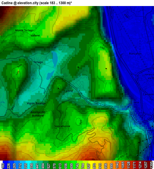
Below is the Elevation map of Cadine, which displays elevation range with different colors. Scale of the first map is from 183 to 1300 m (600 to 4265 ft) with average elevation of 556.9 meters (=1827 ft) [note 1]
These maps also provides idea of topography and contour of this city, they are displayed at different zoom levels. More info about maps, scale and edge coordinates you can find below images.
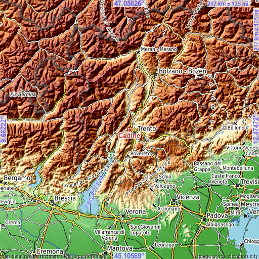
| \ | Map #1 | Topo.Map |
| Scale [m] | 183..1300 m | × |
| Scale [ft] | 600..4265 ft | × |
| Average | 556.9 m = 1827 ft | × |
| Width | 6.78 km = 4.2 mi | 216.9 km = 134.8 mi |
| Height | 6.78 km = 4.2 mi | 216.9 km = 134.8 mi |
| ↑Max Latitude | 46.120069° | 47.05626° |
| Latitude at center | 46.0896° | 46.0896° |
| ↓Min Latitude | 46.059114° | 45.10569° |
| ← Min Longitude | 11.024525° | 9.66222° |
| Longitude center | 11.06847° | 11.06847° |
| →Max Longitude | 11.112415° | 12.47472° |
Nearby cities:
Cities around Cadine sort by population:
• Trento elevation 204 m
4.7 km,  120°
120°
• Lavis 229 m
6.6 km,  28°
28°
• Povo 411 m
7.1 km,  110°
110°
• Ravina 222 m
6.5 km,  148°
148°
• Meano 348 m
5.4 km,  44°
44°
• Civezzano 479 m
9 km,  88°
88°
• Zambana 203 m
7.2 km,  17°
17°
• Romagnano 208 m
8.5 km,  160°
160°
• Vezzano 381 m
5.6 km,  257°
257°
• Terlago 460 m
2 km,  295°
295°
• Calavino 403 m
8.1 km,  233°
233°
• Padergnone 265 m
7.3 km,  242°
242°
Multilingual:
 En español:
Cadine elevación 466 m.
 En France:
Cadine élévation 466 m.


Sources and notes:
- [note 1] Map square and city borders are not equal. Map elevation data is calculated only from area inside that square.
- [src 1] Elevation data from geonames database provided with same terms of usage.
- [src 2] The elevation map of Cadine is generated using elevation data from NASA's 3 arcsec (90m) resolution SRTM data.
- [src 3] Base (background) map © OpenStreetMap contributors tiles are generated by Geofabrik and OpenTopoMap.
Copyright & License:
This Cadine Elevation Map is licensed under CC BY-SA. You may reuse any part from this page, if you give a proper credit by linking to this URL:
 More info on terms of use page.