Romagnano elevation
Romagnano (Trentino-Alto Adige, Provincia autonoma di Trento), Italy elevation is 208 meters and Romagnano elevation in feet is 682 ft above sea level [src 1]. Romagnano is a populated place (feature code) with elevation that is 114 meters (374 ft) smaller than average city elevation in Italy.
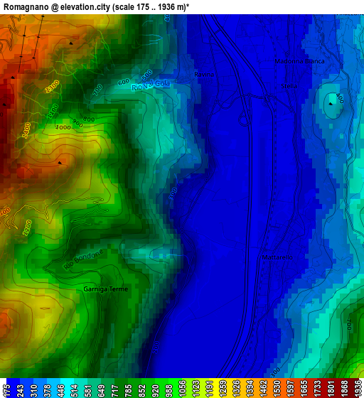
Below is the Elevation map of Romagnano, which displays elevation range with different colors. Scale of the first map is from 175 to 1936 m (574 to 6352 ft) with average elevation of 600.4 meters (=1970 ft) [note 1]
These maps also provides idea of topography and contour of this city, they are displayed at different zoom levels. More info about maps, scale and edge coordinates you can find below images.
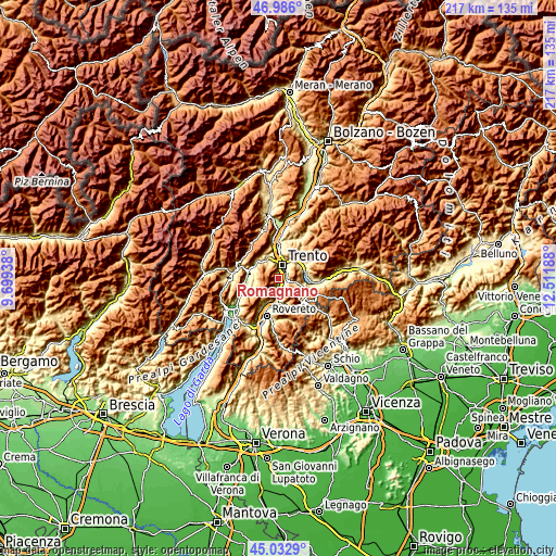
| \ | Map #1 | Topo.Map |
| Scale [m] | 175..1936 m | × |
| Scale [ft] | 574..6352 ft | × |
| Average | 600.4 m = 1970 ft | × |
| Width | 6.79 km = 4.2 mi | 217.2 km = 135 mi |
| Height | 6.79 km = 4.2 mi | 217.2 km = 135 mi |
| ↑Max Latitude | 46.048579° | 46.986° |
| Latitude at center | 46.01807° | 46.01807° |
| ↓Min Latitude | 45.987545° | 45.0329° |
| ← Min Longitude | 11.061685° | 9.69938° |
| Longitude center | 11.10563° | 11.10563° |
| →Max Longitude | 11.149575° | 12.51188° |
Nearby cities:
Cities around Romagnano sort by population:
• Trento elevation 204 m
5.7 km,  12°
12°
• Mattarello 199 m
2.1 km,  119°
119°
• Povo 411 m
6.6 km,  35°
35°
• Ravina 222 m
2.4 km, 11°
• Aldeno 205 m
4.6 km,  192°
192°
• Besenello 220 m
8.3 km,  178°
178°
• Vigolo Vattaro 725 m
7.3 km,  101°
101°
• Cadine 466 m
8.5 km,  340°
340°
• Vattaro 694 m
9.1 km,  107°
107°
• Covelo 535 m
5.1 km,  212°
212°
• Garniga Nuova 814 m
2.2 km,  220°
220°
• Cimoneri 678 m
4.6 km, 214°
Multilingual:
 En español:
Romagnano elevación 208 m.
 En France:
Romagnano élévation 208 m.
 Auf Deutsch:
Romagnano höhe über dem Meeresspiegel ist 208 m.

Sources and notes:
- [note 1] Map square and city borders are not equal. Map elevation data is calculated only from area inside that square.
- [src 1] Elevation data from geonames database provided with same terms of usage.
- [src 2] The elevation map of Romagnano is generated using elevation data from NASA's 3 arcsec (90m) resolution SRTM data.
- [src 3] Base (background) map © OpenStreetMap contributors tiles are generated by Geofabrik and OpenTopoMap.
Copyright & License:
This Romagnano Elevation Map is licensed under CC BY-SA. You may reuse any part from this page, if you give a proper credit by linking to this URL:
 More info on terms of use page.