Calavino elevation
Calavino (Trentino-Alto Adige, Provincia autonoma di Trento), Italy elevation is 403 meters and Calavino elevation in feet is 1322 ft above sea level [src 1]. Calavino is a seat of a third-order administrative division (feature code) with elevation that is 81 meters (266 ft) bigger than average city elevation in Italy.
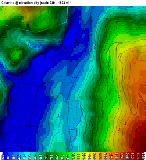
Below is the Elevation map of Calavino, which displays elevation range with different colors. Scale of the first map is from 239 to 1823 m (784 to 5981 ft) with average elevation of 689.3 meters (=2261 ft) [note 1]
These maps also provides idea of topography and contour of this city, they are displayed at different zoom levels. More info about maps, scale and edge coordinates you can find below images.
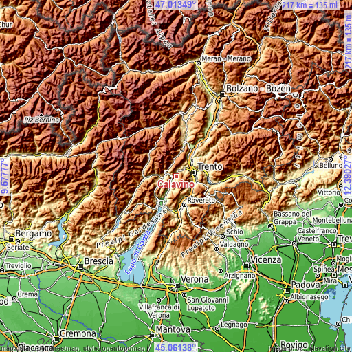
| \ | Map #1 | Topo.Map |
| Scale [m] | 239..1823 m | × |
| Scale [ft] | 784..5981 ft | × |
| Average | 689.3 m = 2261 ft | × |
| Width | 6.78 km = 4.2 mi | 217.1 km = 134.9 mi |
| Height | 6.78 km = 4.2 mi | 217 km = 134.8 mi |
| ↑Max Latitude | 46.076553° | 47.01349° |
| Latitude at center | 46.04606° | 46.04606° |
| ↓Min Latitude | 46.01555° | 45.06138° |
| ← Min Longitude | 10.940075° | 9.57777° |
| Longitude center | 10.98402° | 10.98402° |
| →Max Longitude | 11.027965° | 12.39027° |
Nearby cities:
Cities around Calavino sort by population:
• Cadine elevation 466 m
8.1 km,  53°
53°
• Vezzano 381 m
3.8 km,  15°
15°
• San Lorenzo in Banale 729 m
6.7 km,  300°
300°
• Pietramurata 249 m
4.3 km,  227°
227°
• Cavedine 515 m
5.7 km,  188°
188°
• Terlago 460 m
7.4 km,  39°
39°
• Ponte Arche 404 m
8.6 km,  262°
262°
• Padergnone 265 m
1.5 km,  2°
2°
• Lasino 453 m
2.4 km,  180°
180°
• Drena 377 m
9 km,  199°
199°
• Dorsino 636 m
7.3 km,  293°
293°
• Garniga Nuova 814 m
9.3 km,  120°
120°
Multilingual:
 En español:
Calavino elevación 403 m.
 En France:
Calavino élévation 403 m.
 Auf Deutsch:
Calavino höhe über dem Meeresspiegel ist 403 m.

Sources and notes:
- [note 1] Map square and city borders are not equal. Map elevation data is calculated only from area inside that square.
- [src 1] Elevation data from geonames database provided with same terms of usage.
- [src 2] The elevation map of Calavino is generated using elevation data from NASA's 3 arcsec (90m) resolution SRTM data.
- [src 3] Base (background) map © OpenStreetMap contributors tiles are generated by Geofabrik and OpenTopoMap.
Copyright & License:
This Calavino Elevation Map is licensed under CC BY-SA. You may reuse any part from this page, if you give a proper credit by linking to this URL:
 More info on terms of use page.