Calliano elevation
Calliano (Piedmont, Provincia di Asti), Italy elevation is 263 meters and Calliano elevation in feet is 863 ft above sea level [src 1]. Calliano is a seat of a third-order administrative division (feature code) with elevation that is 59 meters (194 ft) smaller than average city elevation in Italy.
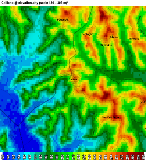
Below is the Elevation map of Calliano, which displays elevation range with different colors. Scale of the first map is from 134 to 303 m (440 to 994 ft) with average elevation of 201.4 meters (=661 ft) [note 1]
These maps also provides idea of topography and contour of this city, they are displayed at different zoom levels. More info about maps, scale and edge coordinates you can find below images.
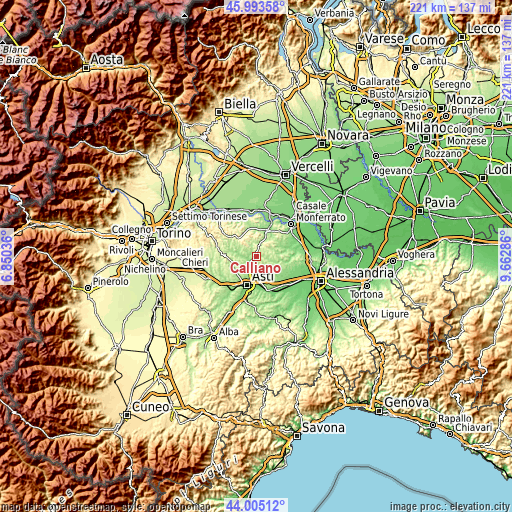
| \ | Map #1 | Topo.Map |
| Scale [m] | 134..303 m | × |
| Scale [ft] | 440..994 ft | × |
| Average | 201.4 m = 661 ft | × |
| Width | 6.91 km = 4.3 mi | 221.1 km = 137.4 mi |
| Height | 6.91 km = 4.3 mi | 221.1 km = 137.4 mi |
| ↑Max Latitude | 45.039041° | 45.99358° |
| Latitude at center | 45.00798° | 45.00798° |
| ↓Min Latitude | 44.976902° | 44.00512° |
| ← Min Longitude | 8.212665° | 6.85036° |
| Longitude center | 8.25661° | 8.25661° |
| →Max Longitude | 8.300555° | 9.66286° |
Nearby cities:
Cities around Calliano sort by population:
• Moncalvo elevation 291 m
4.8 km,  5°
5°
• Castell'Alfero 138 m
3.7 km,  225°
225°
• Montemagno 259 m
6.1 km,  117°
117°
• Portacomaro 226 m
5.7 km,  178°
178°
• Tonco 258 m
5.6 km,  288°
288°
• Castagnole Monferrato 242 m
6.7 km,  145°
145°
• Casorzo 254 m
6.6 km,  76°
76°
• Grana 279 m
3.5 km,  107°
107°
• Grazzano Badoglio 256 m
5.6 km,  50°
50°
• Scurzolengo 233 m
5.1 km,  159°
159°
• Alfiano Natta 276 m
6 km,  319°
319°
• Penango 255 m
2.8 km,  352°
352°
Multilingual:
 En español:
Calliano elevación 263 m.
 En France:
Calliano élévation 263 m.
 Auf Deutsch:
Calliano höhe über dem Meeresspiegel ist 263 m.

Sources and notes:
- [note 1] Map square and city borders are not equal. Map elevation data is calculated only from area inside that square.
- [src 1] Elevation data from geonames database provided with same terms of usage.
- [src 2] The elevation map of Calliano is generated using elevation data from NASA's 3 arcsec (90m) resolution SRTM data.
- [src 3] Base (background) map © OpenStreetMap contributors tiles are generated by Geofabrik and OpenTopoMap.
Copyright & License:
This Calliano Elevation Map is licensed under CC BY-SA. You may reuse any part from this page, if you give a proper credit by linking to this URL:
 More info on terms of use page.