Montemagno elevation
Montemagno (Piedmont, Provincia di Asti), Italy elevation is 259 meters and Montemagno elevation in feet is 850 ft above sea level [src 1]. Montemagno is a seat of a third-order administrative division (feature code) with elevation that is 63 meters (207 ft) smaller than average city elevation in Italy.
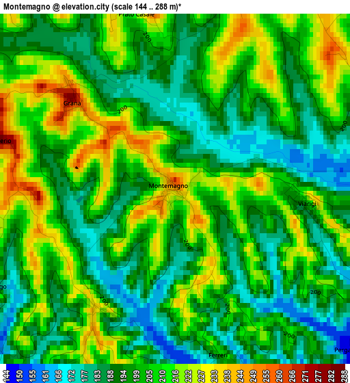
Below is the Elevation map of Montemagno, which displays elevation range with different colors. Scale of the first map is from 144 to 288 m (472 to 945 ft) with average elevation of 201.8 meters (=662 ft) [note 1]
These maps also provides idea of topography and contour of this city, they are displayed at different zoom levels. More info about maps, scale and edge coordinates you can find below images.
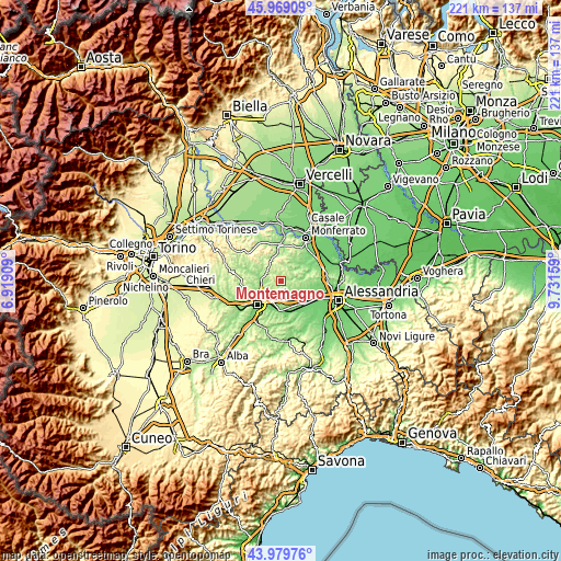
| \ | Map #1 | Topo.Map |
| Scale [m] | 144..288 m | × |
| Scale [ft] | 472..945 ft | × |
| Average | 201.8 m = 662 ft | × |
| Width | 6.91 km = 4.3 mi | 221.2 km = 137.4 mi |
| Height | 6.91 km = 4.3 mi | 221.2 km = 137.4 mi |
| ↑Max Latitude | 45.014125° | 45.96909° |
| Latitude at center | 44.98305° | 44.98305° |
| ↓Min Latitude | 44.951958° | 43.97976° |
| ← Min Longitude | 8.281395° | 6.91909° |
| Longitude center | 8.32534° | 8.32534° |
| →Max Longitude | 8.369285° | 9.73159° |
Nearby cities:
Cities around Montemagno sort by population:
• Refrancore elevation 153 m
5.3 km,  166°
166°
• Portacomaro 226 m
6.1 km,  240°
240°
• Calliano 263 m
6.1 km,  297°
297°
• Castagnole Monferrato 242 m
3.1 km,  210°
210°
• Vignale Monferrato 286 m
6.4 km,  62°
62°
• Casorzo 254 m
4.4 km,  13°
13°
• Grana 279 m
2.7 km,  309°
309°
• Viarigi 210 m
2.5 km,  96°
96°
• Grazzano Badoglio 256 m
6.4 km,  349°
349°
• Scurzolengo 233 m
4.2 km, 240°
• Altavilla Monferrato 241 m
4.1 km,  73°
73°
• Olivola 270 m
6.9 km,  29°
29°
Multilingual:
 En español:
Montemagno elevación 259 m.
 En France:
Montemagno élévation 259 m.
 Auf Deutsch:
Montemagno höhe über dem Meeresspiegel ist 259 m.

Sources and notes:
- [note 1] Map square and city borders are not equal. Map elevation data is calculated only from area inside that square.
- [src 1] Elevation data from geonames database provided with same terms of usage.
- [src 2] The elevation map of Montemagno is generated using elevation data from NASA's 3 arcsec (90m) resolution SRTM data.
- [src 3] Base (background) map © OpenStreetMap contributors tiles are generated by Geofabrik and OpenTopoMap.
Copyright & License:
This Montemagno Elevation Map is licensed under CC BY-SA. You may reuse any part from this page, if you give a proper credit by linking to this URL:
 More info on terms of use page.