Tonco elevation
Tonco (Piedmont, Provincia di Asti), Italy elevation is 258 meters and Tonco elevation in feet is 846 ft above sea level [src 1]. Tonco is a seat of a third-order administrative division (feature code) with elevation that is 64 meters (210 ft) smaller than average city elevation in Italy.
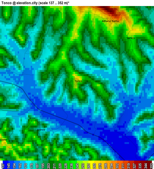
Below is the Elevation map of Tonco, which displays elevation range with different colors. Scale of the first map is from 137 to 352 m (449 to 1155 ft) with average elevation of 193.7 meters (=635 ft) [note 1]
These maps also provides idea of topography and contour of this city, they are displayed at different zoom levels. More info about maps, scale and edge coordinates you can find below images.
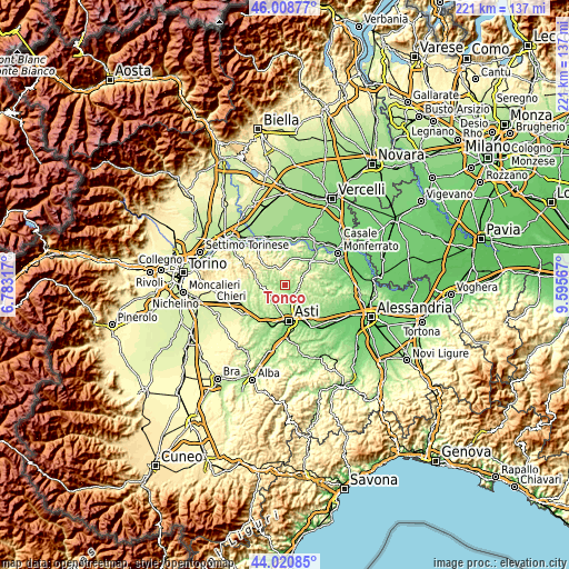
| \ | Map #1 | Topo.Map |
| Scale [m] | 137..352 m | × |
| Scale [ft] | 449..1155 ft | × |
| Average | 193.7 m = 635 ft | × |
| Width | 6.91 km = 4.3 mi | 221 km = 137.3 mi |
| Height | 6.91 km = 4.3 mi | 221 km = 137.3 mi |
| ↑Max Latitude | 45.054493° | 46.00877° |
| Latitude at center | 45.02344° | 45.02344° |
| ↓Min Latitude | 44.99237° | 44.02085° |
| ← Min Longitude | 8.145475° | 6.78317° |
| Longitude center | 8.18942° | 8.18942° |
| →Max Longitude | 8.233365° | 9.59567° |
Nearby cities:
Cities around Tonco sort by population:
• Moncalvo elevation 291 m
6.5 km,  62°
62°
• Montechiaro d'Asti 270 m
6.3 km,  253°
253°
• Castell'Alfero 138 m
5 km,  148°
148°
• Calliano 263 m
5.6 km,  108°
108°
• Cossombrato 258 m
5.5 km,  226°
226°
• Odalengo Piccolo 285 m
5.5 km,  13°
13°
• Villa San Secondo 269 m
4.8 km,  244°
244°
• Alfiano Natta 276 m
3.1 km,  26°
26°
• Villadeati 375 m
5.7 km,  342°
342°
• Frinco 173 m
2.6 km,  212°
212°
• Penango 255 m
5 km,  77°
77°
• Corsione 277 m
4.3 km, 234°
Multilingual:
 En español:
Tonco elevación 258 m.
 En France:
Tonco élévation 258 m.


Sources and notes:
- [note 1] Map square and city borders are not equal. Map elevation data is calculated only from area inside that square.
- [src 1] Elevation data from geonames database provided with same terms of usage.
- [src 2] The elevation map of Tonco is generated using elevation data from NASA's 3 arcsec (90m) resolution SRTM data.
- [src 3] Base (background) map © OpenStreetMap contributors tiles are generated by Geofabrik and OpenTopoMap.
Copyright & License:
This Tonco Elevation Map is licensed under CC BY-SA. You may reuse any part from this page, if you give a proper credit by linking to this URL:
 More info on terms of use page.