Pieve al Toppo elevation
Pieve al Toppo (Tuscany, Province of Arezzo), Italy elevation is 250 meters and Pieve al Toppo elevation in feet is 820 ft above sea level [src 1]. Pieve al Toppo is a populated place (feature code) with elevation that is 72 meters (236 ft) smaller than average city elevation in Italy.
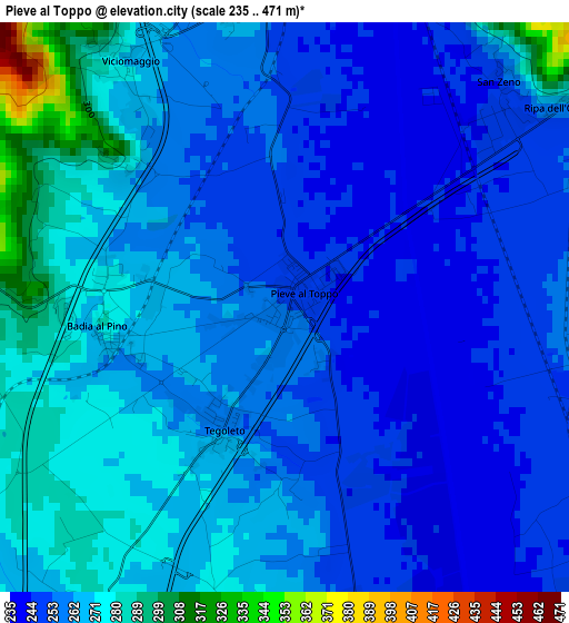
Below is the Elevation map of Pieve al Toppo, which displays elevation range with different colors. Scale of the first map is from 235 to 471 m (771 to 1545 ft) with average elevation of 262.3 meters (=861 ft) [note 1]
These maps also provides idea of topography and contour of this city, they are displayed at different zoom levels. More info about maps, scale and edge coordinates you can find below images.
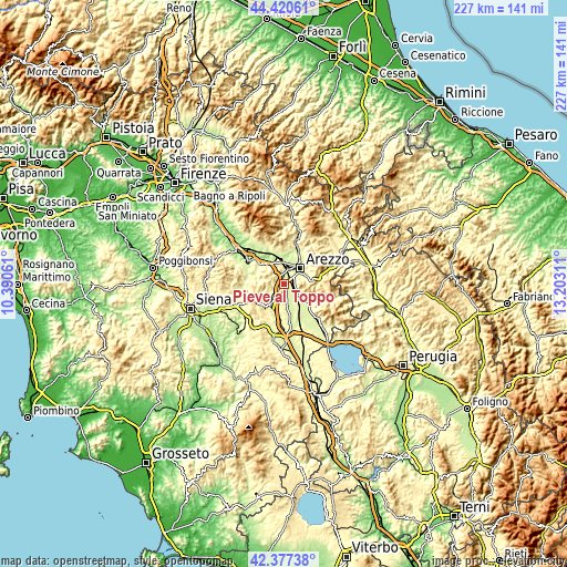
| \ | Map #1 | Topo.Map |
| Scale [m] | 235..471 m | × |
| Scale [ft] | 771..1545 ft | × |
| Average | 262.3 m = 861 ft | × |
| Width | 7.1 km = 4.4 mi | 227.2 km = 141.2 mi |
| Height | 7.1 km = 4.4 mi | 227.2 km = 141.2 mi |
| ↑Max Latitude | 43.439527° | 44.42061° |
| Latitude at center | 43.40761° | 43.40761° |
| ↓Min Latitude | 43.375676° | 42.37738° |
| ← Min Longitude | 11.752915° | 10.39061° |
| Longitude center | 11.79686° | 11.79686° |
| →Max Longitude | 11.840805° | 13.20311° |
Nearby cities:
Cities around Pieve al Toppo sort by population:
• Arezzo elevation 264 m
9.1 km,  47°
47°
• Monte San Savino 305 m
10.1 km,  214°
214°
• Pratantico-Indicatore 255 m
8.2 km,  4°
4°
• Battifolle-Ruscello-Poggiola 250 m
4.7 km, 3°
• Ponticino 259 m
10.4 km,  321°
321°
• Cesa 249 m
10.2 km,  172°
172°
• Tegoleto 258 m
1.7 km, 212°
• Quarata 248 m
10.4 km,  13°
13°
• Badia al Pino 268 m
2 km,  259°
259°
• Viciomaggio 273 m
3.3 km,  325°
325°
• Marciano 300 m
11.2 km,  182°
182°
• Civitella in Val di Chiana 507 m
6.1 km,  280°
280°
Multilingual:
 En español:
Pieve al Toppo elevación 250 m.
 En France:
Pieve al Toppo élévation 250 m.
 Auf Deutsch:
Pieve al Toppo höhe über dem Meeresspiegel ist 250 m.

Sources and notes:
- [note 1] Map square and city borders are not equal. Map elevation data is calculated only from area inside that square.
- [src 1] Elevation data from geonames database provided with same terms of usage.
- [src 2] The elevation map of Pieve al Toppo is generated using elevation data from NASA's 3 arcsec (90m) resolution SRTM data.
- [src 3] Base (background) map © OpenStreetMap contributors tiles are generated by Geofabrik and OpenTopoMap.
Copyright & License:
This Pieve al Toppo Elevation Map is licensed under CC BY-SA. You may reuse any part from this page, if you give a proper credit by linking to this URL:
 More info on terms of use page.