Pratantico-Indicatore elevation
Pratantico-Indicatore (Tuscany, Province of Arezzo), Italy elevation is 255 meters and Pratantico-Indicatore elevation in feet is 837 ft above sea level [src 1]. Pratantico-Indicatore is a populated place (feature code) with elevation that is 67 meters (220 ft) smaller than average city elevation in Italy.
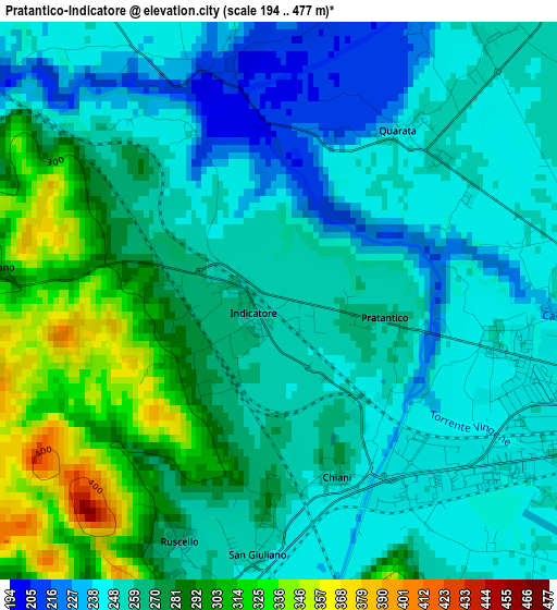
Below is the Elevation map of Pratantico-Indicatore, which displays elevation range with different colors. Scale of the first map is from 194 to 477 m (636 to 1565 ft) with average elevation of 265.8 meters (=872 ft) [note 1]
These maps also provides idea of topography and contour of this city, they are displayed at different zoom levels. More info about maps, scale and edge coordinates you can find below images.
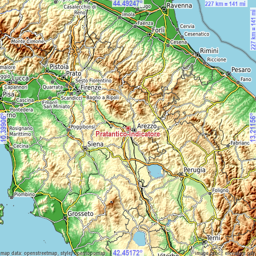
| \ | Map #1 | Topo.Map |
| Scale [m] | 194..477 m | × |
| Scale [ft] | 636..1565 ft | × |
| Average | 265.8 m = 872 ft | × |
| Width | 7.09 km = 4.4 mi | 226.9 km = 141 mi |
| Height | 7.09 km = 4.4 mi | 226.9 km = 141 mi |
| ↑Max Latitude | 43.512589° | 44.49247° |
| Latitude at center | 43.48071° | 43.48071° |
| ↓Min Latitude | 43.448815° | 42.45172° |
| ← Min Longitude | 11.761365° | 10.39906° |
| Longitude center | 11.80531° | 11.80531° |
| →Max Longitude | 11.849255° | 13.21156° |
Nearby cities:
Cities around Pratantico-Indicatore sort by population:
• Arezzo elevation 264 m
6.4 km,  108°
108°
• Battifolle-Ruscello-Poggiola 250 m
3.4 km,  187°
187°
• Castiglion Fibocchi 276 m
6.3 km,  325°
325°
• Chiassa-Tregozzano 288 m
7.8 km,  62°
62°
• Giovi-Ponte alla Chiassa 248 m
7 km,  43°
43°
• Pieve al Toppo 250 m
8.2 km,  184°
184°
• Ponticino 259 m
7.2 km,  269°
269°
• Tegoleto 258 m
9.7 km, 189°
• Laterina 177 m
7.5 km,  288°
288°
• Quarata 248 m
2.7 km, 41°
• Badia al Pino 268 m
8.9 km,  197°
197°
• Viciomaggio 273 m
6 km,  205°
205°
Multilingual:
 En español:
Pratantico-Indicatore elevación 255 m.
 En France:
Pratantico-Indicatore élévation 255 m.
 Auf Deutsch:
Pratantico-Indicatore höhe über dem Meeresspiegel ist 255 m.
 На русском:
Pratantico-Indicatore высота над уровнем моря 255 м
Sources and notes:
- [note 1] Map square and city borders are not equal. Map elevation data is calculated only from area inside that square.
- [src 1] Elevation data from geonames database provided with same terms of usage.
- [src 2] The elevation map of Pratantico-Indicatore is generated using elevation data from NASA's 3 arcsec (90m) resolution SRTM data.
- [src 3] Base (background) map © OpenStreetMap contributors tiles are generated by Geofabrik and OpenTopoMap.
Copyright & License:
This Pratantico-Indicatore Elevation Map is licensed under CC BY-SA. You may reuse any part from this page, if you give a proper credit by linking to this URL:
 More info on terms of use page.