Cesa elevation
Cesa (Tuscany, Province of Arezzo), Italy elevation is 249 meters and Cesa elevation in feet is 817 ft above sea level [src 1]. Cesa is a populated place (feature code) with elevation that is 73 meters (240 ft) smaller than average city elevation in Italy.
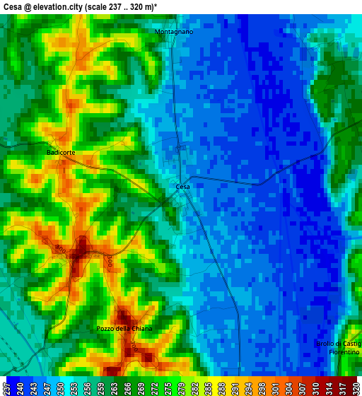
Below is the Elevation map of Cesa, which displays elevation range with different colors. Scale of the first map is from 237 to 320 m (778 to 1050 ft) with average elevation of 260.2 meters (=854 ft) [note 1]
These maps also provides idea of topography and contour of this city, they are displayed at different zoom levels. More info about maps, scale and edge coordinates you can find below images.
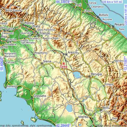
| \ | Map #1 | Topo.Map |
| Scale [m] | 237..320 m | × |
| Scale [ft] | 778..1050 ft | × |
| Average | 260.2 m = 854 ft | × |
| Width | 7.11 km = 4.4 mi | 227.5 km = 141.4 mi |
| Height | 7.11 km = 4.4 mi | 227.5 km = 141.4 mi |
| ↑Max Latitude | 43.348205° | 44.33078° |
| Latitude at center | 43.31624° | 43.31624° |
| ↓Min Latitude | 43.284258° | 42.28448° |
| ← Min Longitude | 11.768675° | 10.40637° |
| Longitude center | 11.81262° | 11.81262° |
| →Max Longitude | 11.856565° | 13.21887° |
Nearby cities:
Cities around Cesa sort by population:
• Castiglion Fiorentino elevation 289 m
9.2 km,  71°
71°
• Sinalunga 267 m
12.5 km,  205°
205°
• Foiano della Chiana 307 m
7 km,  177°
177°
• Monte San Savino 305 m
7.2 km,  284°
284°
• Marciano della Chiana 318 m
2.5 km,  239°
239°
• Bettolle 297 m
12.2 km, 183°
• Lucignano 380 m
7.3 km,  228°
228°
• Pieve al Toppo 250 m
10.2 km,  352°
352°
• Tegoleto 258 m
9 km, 345°
• Badia al Pino 268 m
10.3 km,  341°
341°
• Guazzino 287 m
11.8 km,  192°
192°
• Marciano 300 m
2 km, 237°
Multilingual:
 En español:
Cesa elevación 249 m.
 En France:
Cesa élévation 249 m.


Sources and notes:
- [note 1] Map square and city borders are not equal. Map elevation data is calculated only from area inside that square.
- [src 1] Elevation data from geonames database provided with same terms of usage.
- [src 2] The elevation map of Cesa is generated using elevation data from NASA's 3 arcsec (90m) resolution SRTM data.
- [src 3] Base (background) map © OpenStreetMap contributors tiles are generated by Geofabrik and OpenTopoMap.
Copyright & License:
This Cesa Elevation Map is licensed under CC BY-SA. You may reuse any part from this page, if you give a proper credit by linking to this URL:
 More info on terms of use page.