Lucignano elevation
Lucignano (Tuscany, Province of Arezzo), Italy elevation is 380 meters and Lucignano elevation in feet is 1247 ft above sea level [src 1]. Lucignano is a seat of a third-order administrative division (feature code) with elevation that is 58 meters (190 ft) bigger than average city elevation in Italy.
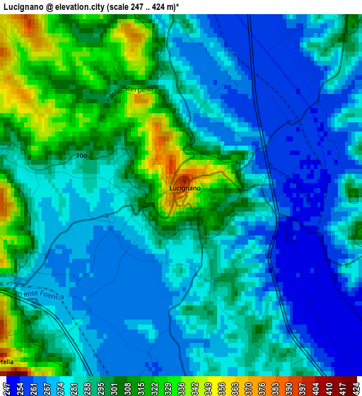
Below is the Elevation map of Lucignano, which displays elevation range with different colors. Scale of the first map is from 247 to 424 m (810 to 1391 ft) with average elevation of 287.5 meters (=943 ft) [note 1]
These maps also provides idea of topography and contour of this city, they are displayed at different zoom levels. More info about maps, scale and edge coordinates you can find below images.
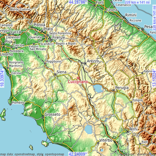
| \ | Map #1 | Topo.Map |
| Scale [m] | 247..424 m | × |
| Scale [ft] | 810..1391 ft | × |
| Average | 287.5 m = 943 ft | × |
| Width | 7.12 km = 4.4 mi | 227.7 km = 141.5 mi |
| Height | 7.12 km = 4.4 mi | 227.7 km = 141.5 mi |
| ↑Max Latitude | 43.304578° | 44.28786° |
| Latitude at center | 43.27259° | 43.27259° |
| ↓Min Latitude | 43.240585° | 42.24009° |
| ← Min Longitude | 11.702045° | 10.33974° |
| Longitude center | 11.74599° | 11.74599° |
| →Max Longitude | 11.789935° | 13.15224° |
Nearby cities:
Cities around Lucignano sort by population:
• Sinalunga elevation 267 m
6.4 km,  180°
180°
• Foiano della Chiana 307 m
6.1 km,  110°
110°
• Torrita di Siena 263 m
11.5 km,  164°
164°
• Monte San Savino 305 m
6.8 km,  346°
346°
• Rapolano Terme 300 m
11.9 km,  282°
282°
• Marciano della Chiana 318 m
4.9 km,  42°
42°
• Bettolle 297 m
8.7 km,  147°
147°
• Serre di Rapolano 339 m
10.6 km,  260°
260°
• Cesa 249 m
7.3 km,  48°
48°
• Guazzino 287 m
7.3 km, 156°
• Marciano 300 m
5.3 km, 44°
• Trequanda 434 m
11.4 km,  213°
213°
Multilingual:
 En español:
Lucignano elevación 380 m.
 En France:
Lucignano élévation 380 m.
 Auf Deutsch:
Lucignano höhe über dem Meeresspiegel ist 380 m.

Sources and notes:
- [note 1] Map square and city borders are not equal. Map elevation data is calculated only from area inside that square.
- [src 1] Elevation data from geonames database provided with same terms of usage.
- [src 2] The elevation map of Lucignano is generated using elevation data from NASA's 3 arcsec (90m) resolution SRTM data.
- [src 3] Base (background) map © OpenStreetMap contributors tiles are generated by Geofabrik and OpenTopoMap.
Copyright & License:
This Lucignano Elevation Map is licensed under CC BY-SA. You may reuse any part from this page, if you give a proper credit by linking to this URL:
 More info on terms of use page.