Cingoli elevation
Cingoli (The Marches, Provincia di Macerata), Italy elevation is 593 meters and Cingoli elevation in feet is 1946 ft above sea level [src 1]. Cingoli is a seat of a third-order administrative division (feature code) with elevation that is 271 meters (889 ft) bigger than average city elevation in Italy.
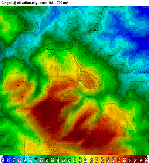
Below is the Elevation map of Cingoli, which displays elevation range with different colors. Scale of the first map is from 166 to 792 m (545 to 2598 ft) with average elevation of 453.8 meters (=1489 ft) [note 1]
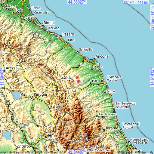
These maps also provides idea of topography and contour of this city, they are displayed at different zoom levels. More info about maps, scale and edge coordinates you can find below images.
| \ | Map #1 | Topo.Map |
| Scale [m] | 166..792 m | × |
| Scale [ft] | 545..2598 ft | × |
| Average | 453.8 m = 1489 ft | × |
| Width | 7.1 km = 4.4 mi | 227.3 km = 141.2 mi |
| Height | 7.1 km = 4.4 mi | 227.3 km = 141.2 mi |
| ↑Max Latitude | 43.407664° | 44.38927° |
| Latitude at center | 43.37573° | 43.37573° |
| ↓Min Latitude | 43.343779° | 42.34497° |
| ← Min Longitude | 13.163925° | 11.80162° |
| Longitude center | 13.20787° | 13.20787° |
| →Max Longitude | 13.251815° | 14.61412° |
Nearby cities:
Cities around Cingoli sort by population:
• Cupramontana elevation 442 m
11.2 km,  317°
317°
• Appignano 198 m
11.4 km,  97°
97°
• Treia 262 m
11.2 km,  132°
132°
• Pianello Vallesina 114 m
13 km,  343°
343°
• Strada 307 m
3.2 km,  18°
18°
• Staffolo 440 m
6.7 km, 343°
• Troviggiano 252 m
3.4 km,  84°
84°
• Apiro 517 m
6.5 km,  286°
286°
• Maiolati Spontini 402 m
13.3 km,  327°
327°
• San Paolo di Jesi 223 m
9.2 km, 342°
• Monte Roberto 332 m
13 km, 334°
• Poggio San Vicino 475 m
10.4 km,  269°
269°
Multilingual:
 En español:
Cingoli elevación 593 m.
 En France:
Cingoli élévation 593 m.


Sources and notes:
- [note 1] Map square and city borders are not equal. Map elevation data is calculated only from area inside that square.
- [src 1] Elevation data from geonames database provided with same terms of usage.
- [src 2] The elevation map of Cingoli is generated using elevation data from NASA's 3 arcsec (90m) resolution SRTM data.
- [src 3] Base (background) map © OpenStreetMap contributors tiles are generated by Geofabrik and OpenTopoMap.
Copyright & License:
This Cingoli Elevation Map is licensed under CC BY-SA. You may reuse any part from this page, if you give a proper credit by linking to this URL:
 More info on terms of use page.