Coseano elevation
Coseano (Friuli Venezia Giulia, Provincia di Udine), Italy elevation is 117 meters and Coseano elevation in feet is 384 ft above sea level [src 1]. Coseano is a seat of a third-order administrative division (feature code) with elevation that is 205 meters (673 ft) smaller than average city elevation in Italy.
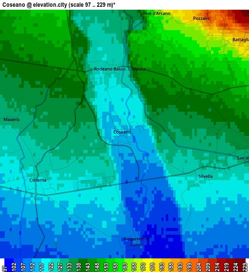
Below is the Elevation map of Coseano, which displays elevation range with different colors. Scale of the first map is from 97 to 229 m (318 to 751 ft) with average elevation of 129.8 meters (=426 ft) [note 1]
These maps also provides idea of topography and contour of this city, they are displayed at different zoom levels. More info about maps, scale and edge coordinates you can find below images.
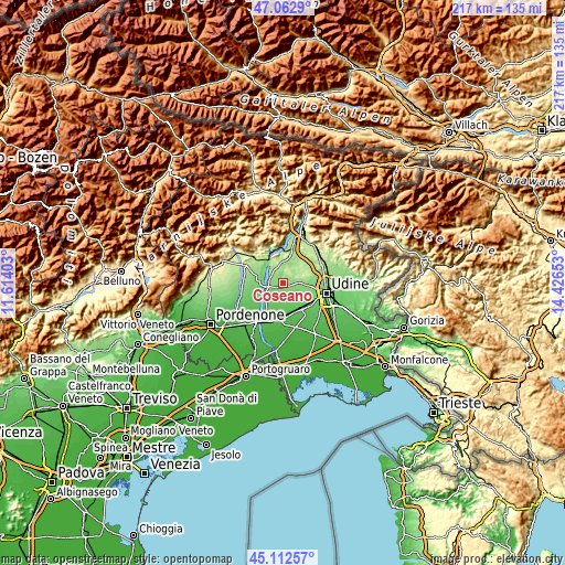
| \ | Map #1 | Topo.Map |
| Scale [m] | 97..229 m | × |
| Scale [ft] | 318..751 ft | × |
| Average | 129.8 m = 426 ft | × |
| Width | 6.78 km = 4.2 mi | 216.9 km = 134.8 mi |
| Height | 6.78 km = 4.2 mi | 216.8 km = 134.7 mi |
| ↑Max Latitude | 46.126825° | 47.0629° |
| Latitude at center | 46.09636° | 46.09636° |
| ↓Min Latitude | 46.065878° | 45.11257° |
| ← Min Longitude | 12.976335° | 11.61403° |
| Longitude center | 13.02028° | 13.02028° |
| →Max Longitude | 13.064225° | 14.42653° |
Nearby cities:
Cities around Coseano sort by population:
• San Daniele del Friuli elevation 216 m
6.8 km,  351°
351°
• Martignacco 131 m
9.2 km,  92°
92°
• Fagagna 160 m
5.8 km,  78°
78°
• San Giacomo 226 m
9 km,  341°
341°
• Rodeano 123 m
1.8 km, 336°
• Villanova 153 m
5.5 km,  316°
316°
• San Vito di Fagagna 131 m
3.6 km,  99°
99°
• Flaibano 100 m
5.1 km,  213°
213°
• Moruzzo 260 m
8.4 km,  72°
72°
• Dignano 109 m
6.3 km,  257°
257°
• Mereto di Tomba 96 m
5.3 km,  159°
159°
• Rive d'Arcano 169 m
3.6 km,  15°
15°
Multilingual:
 En español:
Coseano elevación 117 m.
 En France:
Coseano élévation 117 m.


Sources and notes:
- [note 1] Map square and city borders are not equal. Map elevation data is calculated only from area inside that square.
- [src 1] Elevation data from geonames database provided with same terms of usage.
- [src 2] The elevation map of Coseano is generated using elevation data from NASA's 3 arcsec (90m) resolution SRTM data.
- [src 3] Base (background) map © OpenStreetMap contributors tiles are generated by Geofabrik and OpenTopoMap.
Copyright & License:
This Coseano Elevation Map is licensed under CC BY-SA. You may reuse any part from this page, if you give a proper credit by linking to this URL:
 More info on terms of use page.