San Giacomo elevation
San Giacomo (Friuli Venezia Giulia, Provincia di Udine), Italy elevation is 226 meters and San Giacomo elevation in feet is 741 ft above sea level [src 1]. San Giacomo is a seat of a third-order administrative division (feature code) with elevation that is 96 meters (315 ft) smaller than average city elevation in Italy.
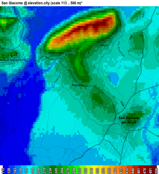
Below is the Elevation map of San Giacomo, which displays elevation range with different colors. Scale of the first map is from 113 to 506 m (371 to 1660 ft) with average elevation of 191.9 meters (=630 ft) [note 1]
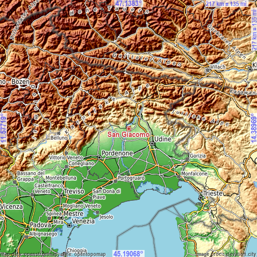
These maps also provides idea of topography and contour of this city, they are displayed at different zoom levels. More info about maps, scale and edge coordinates you can find below images.
| \ | Map #1 | Topo.Map |
| Scale [m] | 113..506 m | × |
| Scale [ft] | 371..1660 ft | × |
| Average | 191.9 m = 630 ft | × |
| Width | 6.77 km = 4.2 mi | 216.6 km = 134.6 mi |
| Height | 6.77 km = 4.2 mi | 216.5 km = 134.5 mi |
| ↑Max Latitude | 46.203533° | 47.1383° |
| Latitude at center | 46.17311° | 46.17311° |
| ↓Min Latitude | 46.14267° | 45.19068° |
| ← Min Longitude | 12.939495° | 11.57719° |
| Longitude center | 12.98344° | 12.98344° |
| →Max Longitude | 13.027385° | 14.38969° |
Nearby cities:
Cities around San Giacomo sort by population:
• San Daniele del Friuli elevation 216 m
2.6 km,  134°
134°
• Majano 168 m
6.2 km,  75°
75°
• Rodeano 123 m
7.2 km,  162°
162°
• Lestans 174 m
7.5 km,  256°
256°
• Villanova 153 m
4.6 km,  192°
192°
• Forgaria nel Friuli 250 m
5.3 km,  352°
352°
• Coseano 117 m
9 km, 161°
• Rive d'Arcano 169 m
6.3 km,  143°
143°
• Pinzano al Tagliamento 203 m
3.2 km,  288°
288°
• Anduins 317 m
6.9 km,  343°
343°
• Paludea 240 m
6.8 km,  295°
295°
• Clauzetto 554 m
8.1 km,  320°
320°
Multilingual:
 En español:
San Giacomo elevación 226 m.
 En France:
San Giacomo élévation 226 m.
 Auf Deutsch:
San Giacomo höhe über dem Meeresspiegel ist 226 m.

Sources and notes:
- [note 1] Map square and city borders are not equal. Map elevation data is calculated only from area inside that square.
- [src 1] Elevation data from geonames database provided with same terms of usage.
- [src 2] The elevation map of San Giacomo is generated using elevation data from NASA's 3 arcsec (90m) resolution SRTM data.
- [src 3] Base (background) map © OpenStreetMap contributors tiles are generated by Geofabrik and OpenTopoMap.
Copyright & License:
This San Giacomo Elevation Map is licensed under CC BY-SA. You may reuse any part from this page, if you give a proper credit by linking to this URL:
 More info on terms of use page.