Fagagna elevation
Fagagna (Friuli Venezia Giulia, Provincia di Udine), Italy elevation is 160 meters and Fagagna elevation in feet is 525 ft above sea level [src 1]. Fagagna is a seat of a third-order administrative division (feature code) with elevation that is 162 meters (531 ft) smaller than average city elevation in Italy.
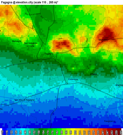
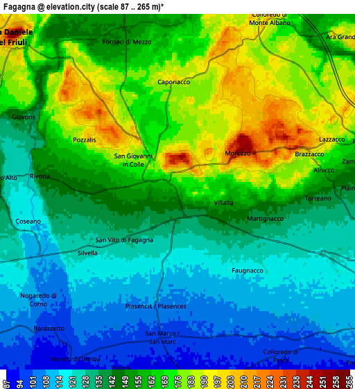
Below is the Elevation map of Fagagna, which displays elevation range with different colors. Scale of the first map is from 110 to 265 m (361 to 869 ft) with average elevation of 160.5 meters (=527 ft) [note 1]
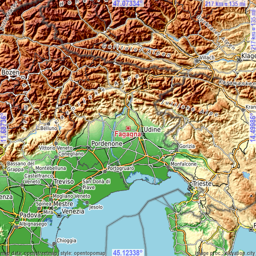
These maps also provides idea of topography and contour of this city, they are displayed at different zoom levels. More info about maps, scale and edge coordinates you can find below images.
| \ | Map #1 | Map #2 | Topo.Map |
| Scale [m] | 110..265 m | 87..265 m | × |
| Scale [ft] | 361..869 ft | 285..869 ft | × |
| Average | 160.5 m = 527 ft | 147.3 m = 483 ft | × |
| Width | 6.78 km = 4.2 mi | 13.55 km = 8.4 mi | 216.8 km = 134.7 mi |
| Height | 6.78 km = 4.2 mi | 13.55 km = 8.4 mi | 216.8 km = 134.7 mi |
| ↑Max Latitude | 46.137439° | 46.167882° | 47.07334° |
| Latitude at center | 46.10698° | 46.10698° | 46.10698° |
| ↓Min Latitude | 46.076504° | 46.046011° | 45.12338° |
| ← Min Longitude | 13.049665° | 13.005719° | 11.68736° |
| Longitude center | 13.09361° | 13.09361° | 13.09361° |
| →Max Longitude | 13.137555° | 13.181501° | 14.49986° |
Nearby cities:
Cities around Fagagna sort by population:
• Martignacco elevation 131 m
3.9 km,  113°
113°
• Pagnacco 150 m
7 km,  83°
83°
• Passons 114 m
8.5 km,  119°
119°
• Colloredo di Monte Albano 199 m
7.3 km,  28°
28°
• Colloredo di Prato 96 m
7.3 km,  147°
147°
• Rodeano 123 m
6.4 km,  273°
273°
• San Vito di Fagagna 131 m
2.8 km,  230°
230°
• Moruzzo 260 m
2.7 km,  58°
58°
• Coseano 117 m
5.8 km,  258°
258°
• Colloredo di Monte Albano-Lauzzana 207 m
6.2 km,  21°
21°
• Mereto di Tomba 96 m
7.3 km,  211°
211°
• Rive d'Arcano 169 m
5.2 km,  295°
295°
Multilingual:
 En español:
Fagagna elevación 160 m.
 En France:
Fagagna élévation 160 m.


Sources and notes:
- [note 1] Map square and city borders are not equal. Map elevation data is calculated only from area inside that square.
- [src 1] Elevation data from geonames database provided with same terms of usage.
- [src 2] The elevation map of Fagagna is generated using elevation data from NASA's 3 arcsec (90m) resolution SRTM data.
- [src 3] Base (background) map © OpenStreetMap contributors tiles are generated by Geofabrik and OpenTopoMap.
Copyright & License:
This Fagagna Elevation Map is licensed under CC BY-SA. You may reuse any part from this page, if you give a proper credit by linking to this URL:
 More info on terms of use page.