Dosimo elevation
Dosimo (Lombardy, Provincia di Cremona), Italy elevation is 45 meters and Dosimo elevation in feet is 148 ft above sea level [src 1]. Dosimo is a seat of a third-order administrative division (feature code) with elevation that is 277 meters (909 ft) smaller than average city elevation in Italy.
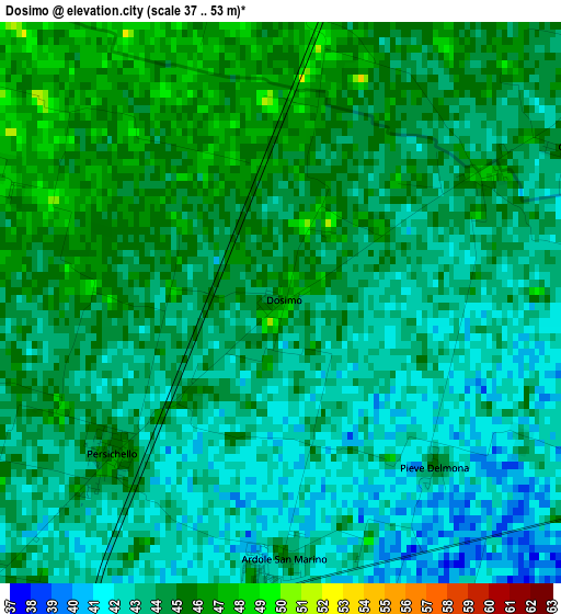
Below is the Elevation map of Dosimo, which displays elevation range with different colors. Scale of the first map is from 37 to 53 m (121 to 174 ft) with average elevation of 43.6 meters (=143 ft) [note 1]
These maps also provides idea of topography and contour of this city, they are displayed at different zoom levels. More info about maps, scale and edge coordinates you can find below images.
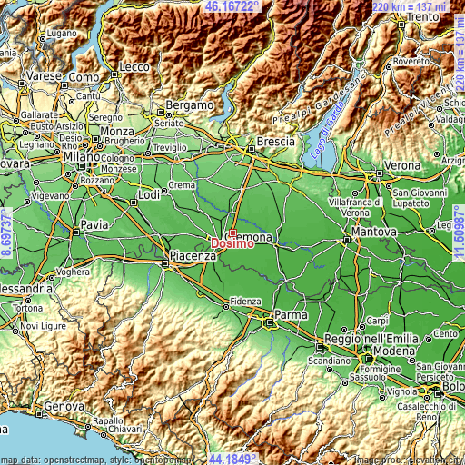
| \ | Map #1 | Topo.Map |
| Scale [m] | 37..53 m | × |
| Scale [ft] | 121..174 ft | × |
| Average | 43.6 m = 143 ft | × |
| Width | 6.89 km = 4.3 mi | 220.4 km = 136.9 mi |
| Height | 6.89 km = 4.3 mi | 220.4 km = 136.9 mi |
| ↑Max Latitude | 45.215655° | 46.16722° |
| Latitude at center | 45.18469° | 45.18469° |
| ↓Min Latitude | 45.153708° | 44.1849° |
| ← Min Longitude | 10.059675° | 8.69737° |
| Longitude center | 10.10362° | 10.10362° |
| →Max Longitude | 10.147565° | 11.50987° |
Nearby cities:
Cities around Dosimo sort by population:
• Vescovato elevation 46 m
4.9 km,  103°
103°
• Persico Dosimo 46 m
0.2 km,  42°
42°
• Boschetto 48 m
6.4 km,  250°
250°
• Gadesco-Pieve Delmona 43 m
3.1 km,  162°
162°
• San Felice 43 m
5.2 km,  206°
206°
• Corte de' Frati 48 m
3.8 km,  357°
357°
• Pozzaglio ed Uniti 49 m
4.5 km,  292°
292°
• Ardole San Marino 44 m
3.2 km,  177°
177°
• Grontardo 46 m
4.2 km,  63°
63°
• Pozzaglio 50 m
4.3 km, 293°
• Malagnino 42 m
5.6 km,  171°
171°
• Scandolara Ripa d'Oglio 48 m
5.9 km,  45°
45°
Multilingual:
 En español:
Dosimo elevación 45 m.
 En France:
Dosimo élévation 45 m.


Sources and notes:
- [note 1] Map square and city borders are not equal. Map elevation data is calculated only from area inside that square.
- [src 1] Elevation data from geonames database provided with same terms of usage.
- [src 2] The elevation map of Dosimo is generated using elevation data from NASA's 3 arcsec (90m) resolution SRTM data.
- [src 3] Base (background) map © OpenStreetMap contributors tiles are generated by Geofabrik and OpenTopoMap.
Copyright & License:
This Dosimo Elevation Map is licensed under CC BY-SA. You may reuse any part from this page, if you give a proper credit by linking to this URL:
 More info on terms of use page.