Corte de' Frati elevation
Corte de' Frati (Lombardy, Provincia di Cremona), Italy elevation is 48 meters and Corte de' Frati elevation in feet is 157 ft above sea level [src 1]. Corte de' Frati is a seat of a third-order administrative division (feature code) with elevation that is 274 meters (899 ft) smaller than average city elevation in Italy.
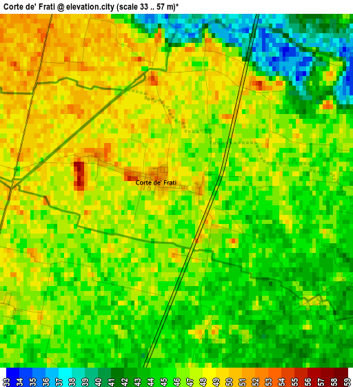
Below is the Elevation map of Corte de' Frati, which displays elevation range with different colors. Scale of the first map is from 33 to 57 m (108 to 187 ft) with average elevation of 45.8 meters (=150 ft) [note 1]
These maps also provides idea of topography and contour of this city, they are displayed at different zoom levels. More info about maps, scale and edge coordinates you can find below images.
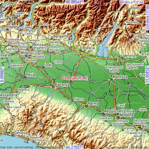
| \ | Map #1 | Topo.Map |
| Scale [m] | 33..57 m | × |
| Scale [ft] | 108..187 ft | × |
| Average | 45.8 m = 150 ft | × |
| Width | 6.88 km = 4.3 mi | 220.3 km = 136.9 mi |
| Height | 6.88 km = 4.3 mi | 220.3 km = 136.9 mi |
| ↑Max Latitude | 45.249417° | 46.20041° |
| Latitude at center | 45.21847° | 45.21847° |
| ↓Min Latitude | 45.187506° | 44.21927° |
| ← Min Longitude | 10.057925° | 8.69562° |
| Longitude center | 10.10187° | 10.10187° |
| →Max Longitude | 10.145815° | 11.50812° |
Nearby cities:
Cities around Corte de' Frati sort by population:
• Pontevico elevation 52 m
6.1 km,  353°
353°
• Persico Dosimo 46 m
3.6 km,  175°
175°
• Alfianello 52 m
6.5 km,  33°
33°
• Robecco d'Oglio 48 m
4.9 km,  336°
336°
• Gadesco-Pieve Delmona 43 m
6.8 km,  170°
170°
• Seniga 46 m
6.6 km,  63°
63°
• Pozzaglio ed Uniti 49 m
4.5 km,  243°
243°
• Grontardo 46 m
4.3 km,  116°
116°
• Olmeneta 53 m
6.4 km,  286°
286°
• Pozzaglio 50 m
4.3 km, 241°
• Dosimo 45 m
3.8 km, 177°
• Scandolara Ripa d'Oglio 48 m
4.3 km,  85°
85°
Multilingual:
 En español:
Corte de' Frati elevación 48 m.
 En France:
Corte de' Frati élévation 48 m.
 Auf Deutsch:
Corte de' Frati höhe über dem Meeresspiegel ist 48 m.

Sources and notes:
- [note 1] Map square and city borders are not equal. Map elevation data is calculated only from area inside that square.
- [src 1] Elevation data from geonames database provided with same terms of usage.
- [src 2] The elevation map of Corte de' Frati is generated using elevation data from NASA's 3 arcsec (90m) resolution SRTM data.
- [src 3] Base (background) map © OpenStreetMap contributors tiles are generated by Geofabrik and OpenTopoMap.
Copyright & License:
This Corte de' Frati Elevation Map is licensed under CC BY-SA. You may reuse any part from this page, if you give a proper credit by linking to this URL:
 More info on terms of use page.