Forenza elevation
Forenza (Basilicate, Provincia di Potenza), Italy elevation is 832 meters and Forenza elevation in feet is 2730 ft above sea level [src 1]. Forenza is a seat of a third-order administrative division (feature code) with elevation that is 510 meters (1673 ft) bigger than average city elevation in Italy.
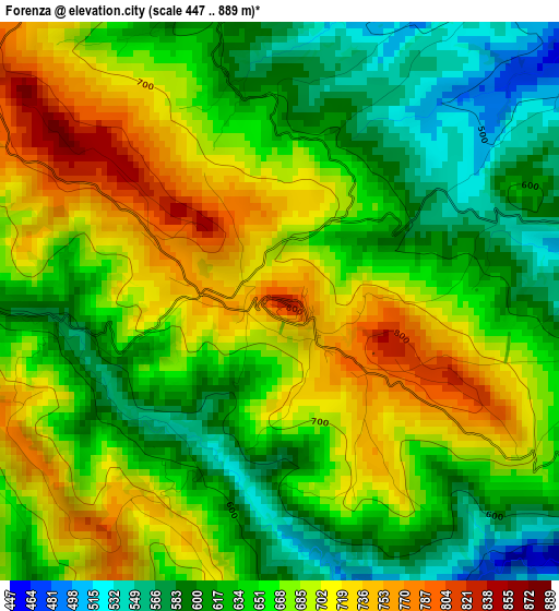
Below is the Elevation map of Forenza, which displays elevation range with different colors. Scale of the first map is from 447 to 889 m (1467 to 2917 ft) with average elevation of 659.3 meters (=2163 ft) [note 1]
These maps also provides idea of topography and contour of this city, they are displayed at different zoom levels. More info about maps, scale and edge coordinates you can find below images.
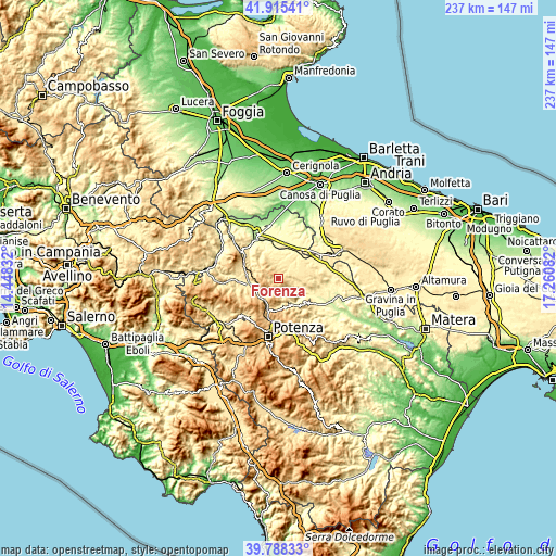
| \ | Map #1 | Topo.Map |
| Scale [m] | 447..889 m | × |
| Scale [ft] | 1467..2917 ft | × |
| Average | 659.3 m = 2163 ft | × |
| Width | 7.39 km = 4.6 mi | 236.5 km = 147 mi |
| Height | 7.39 km = 4.6 mi | 236.5 km = 147 mi |
| ↑Max Latitude | 40.893638° | 41.91541° |
| Latitude at center | 40.86041° | 40.86041° |
| ↓Min Latitude | 40.827166° | 39.78833° |
| ← Min Longitude | 15.810625° | 14.44832° |
| Longitude center | 15.85457° | 15.85457° |
| →Max Longitude | 15.898515° | 17.26082° |
Nearby cities:
Cities around Forenza sort by population:
• Venosa elevation 418 m
11.9 km,  342°
342°
• Genzano di Lucania 595 m
14.9 km,  96°
96°
• Palazzo San Gervasio 472 m
13.3 km,  53°
53°
• Oppido Lucano 701 m
15.7 km,  134°
134°
• Pietragalla 784 m
12.9 km,  172°
172°
• Acerenza 770 m
10.2 km,  136°
136°
• Maschito 594 m
5.8 km, 338°
• Ripacandida 572 m
12.3 km,  298°
298°
• Banzi 566 m
13.1 km,  89°
89°
• Cancellara 690 m
15.6 km,  157°
157°
• Filiano 591 m
13.4 km,  245°
245°
• Ginestra 572 m
12.7 km,  307°
307°
Multilingual:
 En español:
Forenza elevación 832 m.
 En France:
Forenza élévation 832 m.


Sources and notes:
- [note 1] Map square and city borders are not equal. Map elevation data is calculated only from area inside that square.
- [src 1] Elevation data from geonames database provided with same terms of usage.
- [src 2] The elevation map of Forenza is generated using elevation data from NASA's 3 arcsec (90m) resolution SRTM data.
- [src 3] Base (background) map © OpenStreetMap contributors tiles are generated by Geofabrik and OpenTopoMap.
Copyright & License:
This Forenza Elevation Map is licensed under CC BY-SA. You may reuse any part from this page, if you give a proper credit by linking to this URL:
 More info on terms of use page.