Acerenza elevation
Acerenza (Basilicate, Provincia di Potenza), Italy elevation is 770 meters and Acerenza elevation in feet is 2526 ft above sea level [src 1]. Acerenza is a seat of a third-order administrative division (feature code) with elevation that is 448 meters (1470 ft) bigger than average city elevation in Italy.
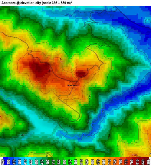
Below is the Elevation map of Acerenza, which displays elevation range with different colors. Scale of the first map is from 336 to 859 m (1102 to 2818 ft) with average elevation of 538.6 meters (=1767 ft) [note 1]
These maps also provides idea of topography and contour of this city, they are displayed at different zoom levels. More info about maps, scale and edge coordinates you can find below images.
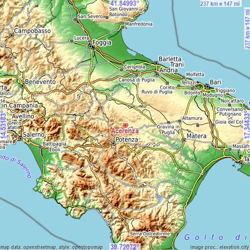
| \ | Map #1 | Topo.Map |
| Scale [m] | 336..859 m | × |
| Scale [ft] | 1102..2818 ft | × |
| Average | 538.6 m = 1767 ft | × |
| Width | 7.4 km = 4.6 mi | 236.7 km = 147.1 mi |
| Height | 7.4 km = 4.6 mi | 236.7 km = 147.1 mi |
| ↑Max Latitude | 40.827121° | 41.84993° |
| Latitude at center | 40.79386° | 40.79386° |
| ↓Min Latitude | 40.760582° | 39.72072° |
| ← Min Longitude | 15.894135° | 14.53183° |
| Longitude center | 15.93808° | 15.93808° |
| →Max Longitude | 15.982025° | 17.34433° |
Nearby cities:
Cities around Acerenza sort by population:
• Genzano di Lucania elevation 595 m
9.7 km,  53°
53°
• Palazzo San Gervasio 472 m
15.7 km,  13°
13°
• Oppido Lucano 701 m
5.5 km,  130°
130°
• Tolve 504 m
12.9 km,  149°
149°
• Pietragalla 784 m
7.6 km,  225°
225°
• Forenza 832 m
10.2 km,  316°
316°
• Maschito 594 m
15.7 km, 324°
• Vaglio Basilicata 927 m
14.3 km,  188°
188°
• San Chirico Nuovo 721 m
17.5 km,  137°
137°
• Banzi 566 m
9.6 km,  39°
39°
• Cancellara 690 m
7.1 km, 189°
• Filiano 591 m
19.3 km,  275°
275°
Multilingual:
 En español:
Acerenza elevación 770 m.
 En France:
Acerenza élévation 770 m.
 Auf Deutsch:
Acerenza höhe über dem Meeresspiegel ist 770 m.

Sources and notes:
- [note 1] Map square and city borders are not equal. Map elevation data is calculated only from area inside that square.
- [src 1] Elevation data from geonames database provided with same terms of usage.
- [src 2] The elevation map of Acerenza is generated using elevation data from NASA's 3 arcsec (90m) resolution SRTM data.
- [src 3] Base (background) map © OpenStreetMap contributors tiles are generated by Geofabrik and OpenTopoMap.
Copyright & License:
This Acerenza Elevation Map is licensed under CC BY-SA. You may reuse any part from this page, if you give a proper credit by linking to this URL:
 More info on terms of use page.