Ripacandida elevation
Ripacandida (Basilicate, Provincia di Potenza), Italy elevation is 572 meters and Ripacandida elevation in feet is 1877 ft above sea level [src 1]. Ripacandida is a seat of a third-order administrative division (feature code) with elevation that is 250 meters (820 ft) bigger than average city elevation in Italy.
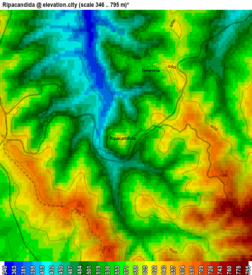
Below is the Elevation map of Ripacandida, which displays elevation range with different colors. Scale of the first map is from 346 to 795 m (1135 to 2608 ft) with average elevation of 556.2 meters (=1825 ft) [note 1]
These maps also provides idea of topography and contour of this city, they are displayed at different zoom levels. More info about maps, scale and edge coordinates you can find below images.
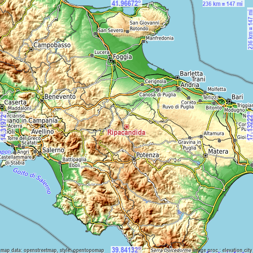
| \ | Map #1 | Topo.Map |
| Scale [m] | 346..795 m | × |
| Scale [ft] | 1135..2608 ft | × |
| Average | 556.2 m = 1825 ft | × |
| Width | 7.39 km = 4.6 mi | 236.3 km = 146.8 mi |
| Height | 7.39 km = 4.6 mi | 236.3 km = 146.8 mi |
| ↑Max Latitude | 40.945762° | 41.96672° |
| Latitude at center | 40.91256° | 40.91256° |
| ↓Min Latitude | 40.879342° | 39.84132° |
| ← Min Longitude | 15.682025° | 14.31972° |
| Longitude center | 15.72597° | 15.72597° |
| →Max Longitude | 15.769915° | 17.13222° |
Nearby cities:
Cities around Ripacandida sort by population:
• Lavello elevation 319 m
15.9 km,  19°
19°
• Melfi 529 m
11 km,  327°
327°
• Rionero in Vulture 634 m
4.8 km,  284°
284°
• Venosa 418 m
9.2 km,  52°
52°
• Rapolla 465 m
8.3 km, 326°
• Atella 496 m
7.3 km,  238°
238°
• Barile 637 m
5.7 km,  306°
306°
• Zona 179 527 m
13.5 km,  318°
318°
• Forenza 832 m
12.3 km,  118°
118°
• Maschito 594 m
8.7 km,  92°
92°
• Filiano 591 m
11.4 km,  186°
186°
• Ginestra 572 m
2.2 km, 20°
Multilingual:
 En español:
Ripacandida elevación 572 m.
 En France:
Ripacandida élévation 572 m.
 Auf Deutsch:
Ripacandida höhe über dem Meeresspiegel ist 572 m.

Sources and notes:
- [note 1] Map square and city borders are not equal. Map elevation data is calculated only from area inside that square.
- [src 1] Elevation data from geonames database provided with same terms of usage.
- [src 2] The elevation map of Ripacandida is generated using elevation data from NASA's 3 arcsec (90m) resolution SRTM data.
- [src 3] Base (background) map © OpenStreetMap contributors tiles are generated by Geofabrik and OpenTopoMap.
Copyright & License:
This Ripacandida Elevation Map is licensed under CC BY-SA. You may reuse any part from this page, if you give a proper credit by linking to this URL:
 More info on terms of use page.