Grosio elevation
Grosio (Lombardy, Provincia di Sondrio), Italy elevation is 666 meters and Grosio elevation in feet is 2185 ft above sea level [src 1]. Grosio is a seat of a third-order administrative division (feature code) with elevation that is 344 meters (1129 ft) bigger than average city elevation in Italy.
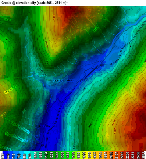
Below is the Elevation map of Grosio, which displays elevation range with different colors. Scale of the first map is from 565 to 2511 m (1854 to 8238 ft) with average elevation of 1276.1 meters (=4187 ft) [note 1]
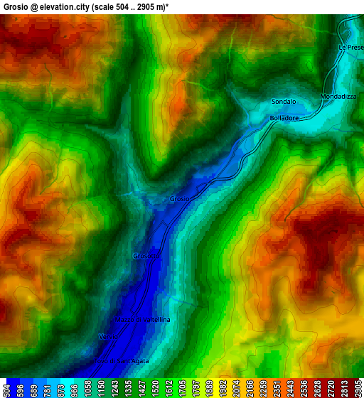
These maps also provides idea of topography and contour of this city, they are displayed at different zoom levels. More info about maps, scale and edge coordinates you can find below images.
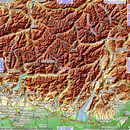
| \ | Map #1 | Map #2 | Topo.Map |
| Scale [m] | 565..2511 m | 504..2905 m | × |
| Scale [ft] | 1854..8238 ft | 1654..9531 ft | × |
| Average | 1276.1 m = 4187 ft | 1653 m = 5423 ft | × |
| Width | 6.75 km = 4.2 mi | 13.5 km = 8.4 mi | 216.1 km = 134.3 mi |
| Height | 6.75 km = 4.2 mi | 13.5 km = 8.4 mi | 216 km = 134.2 mi |
| ↑Max Latitude | 46.330053° | 46.360389° | 47.26264° |
| Latitude at center | 46.2997° | 46.2997° | 46.2997° |
| ↓Min Latitude | 46.26933° | 46.238944° | 45.31952° |
| ← Min Longitude | 10.231775° | 10.187829° | 8.86947° |
| Longitude center | 10.27572° | 10.27572° | 10.27572° |
| →Max Longitude | 10.319665° | 10.363611° | 11.68197° |
Nearby cities:
Cities around Grosio sort by population:
• Tirano elevation 423 m
12.8 km,  222°
222°
• Edolo 672 m
14.2 km,  161°
161°
• Sondalo 880 m
5.2 km,  49°
49°
• Grosotto 603 m
2.4 km,  212°
212°
• Vezza d'Oglio 1035 m
11.6 km,  125°
125°
• Mazzo di Valtellina 553 m
5 km,  198°
198°
• Lovero 509 m
8.4 km, 205°
• Tovo di Sant'Agata 530 m
6.5 km, 200°
• Monno 1074 m
10.9 km,  153°
153°
• Sernio 613 m
10 km, 212°
• Incudine 933 m
10.9 km,  144°
144°
• Vervio 541 m
5.9 km, 207°
Multilingual:
 En español:
Grosio elevación 666 m.
 En France:
Grosio élévation 666 m.


Sources and notes:
- [note 1] Map square and city borders are not equal. Map elevation data is calculated only from area inside that square.
- [src 1] Elevation data from geonames database provided with same terms of usage.
- [src 2] The elevation map of Grosio is generated using elevation data from NASA's 3 arcsec (90m) resolution SRTM data.
- [src 3] Base (background) map © OpenStreetMap contributors tiles are generated by Geofabrik and OpenTopoMap.
Copyright & License:
This Grosio Elevation Map is licensed under CC BY-SA. You may reuse any part from this page, if you give a proper credit by linking to this URL:
 More info on terms of use page.