Sernio elevation
Sernio (Lombardy, Provincia di Sondrio), Italy elevation is 613 meters and Sernio elevation in feet is 2011 ft above sea level [src 1]. Sernio is a seat of a third-order administrative division (feature code) with elevation that is 291 meters (955 ft) bigger than average city elevation in Italy.
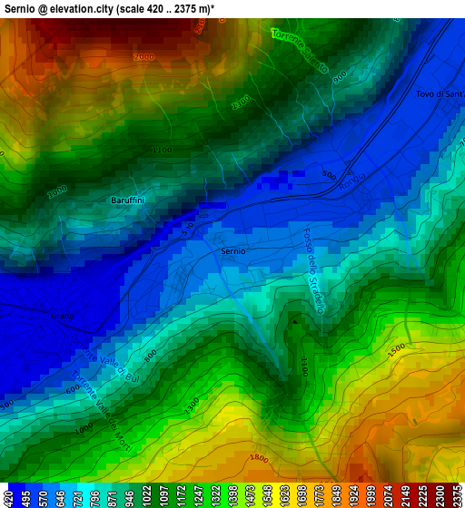
Below is the Elevation map of Sernio, which displays elevation range with different colors. Scale of the first map is from 420 to 2375 m (1378 to 7792 ft) with average elevation of 1082.2 meters (=3551 ft) [note 1]
These maps also provides idea of topography and contour of this city, they are displayed at different zoom levels. More info about maps, scale and edge coordinates you can find below images.
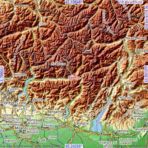
| \ | Map #1 | Topo.Map |
| Scale [m] | 420..2375 m | × |
| Scale [ft] | 1378..7792 ft | × |
| Average | 1082.2 m = 3551 ft | × |
| Width | 6.76 km = 4.2 mi | 216.4 km = 134.5 mi |
| Height | 6.76 km = 4.2 mi | 216.3 km = 134.4 mi |
| ↑Max Latitude | 46.254595° | 47.18848° |
| Latitude at center | 46.2242° | 46.2242° |
| ↓Min Latitude | 46.193789° | 45.24268° |
| ← Min Longitude | 10.161315° | 8.79901° |
| Longitude center | 10.20526° | 10.20526° |
| →Max Longitude | 10.249205° | 11.61151° |
Nearby cities:
Cities around Sernio sort by population:
• Tirano elevation 423 m
3.4 km,  252°
252°
• Grosio 666 m
10 km,  32°
32°
• Villa 405 m
5.9 km, 247°
• Aprica 1176 m
9.1 km,  208°
208°
• Grosotto 603 m
7.6 km, 32°
• Bianzone 441 m
8.5 km,  240°
240°
• Mazzo di Valtellina 553 m
5.3 km,  46°
46°
• Lovero 509 m
2 km,  65°
65°
• Tovo di Sant'Agata 530 m
3.9 km, 53°
• Monno 1074 m
10.5 km,  97°
97°
• Corteno Golgi 934 m
7.1 km,  155°
155°
• Vervio 541 m
4.2 km,  40°
40°
Multilingual:
 En español:
Sernio elevación 613 m.
 En France:
Sernio élévation 613 m.


Sources and notes:
- [note 1] Map square and city borders are not equal. Map elevation data is calculated only from area inside that square.
- [src 1] Elevation data from geonames database provided with same terms of usage.
- [src 2] The elevation map of Sernio is generated using elevation data from NASA's 3 arcsec (90m) resolution SRTM data.
- [src 3] Base (background) map © OpenStreetMap contributors tiles are generated by Geofabrik and OpenTopoMap.
Copyright & License:
This Sernio Elevation Map is licensed under CC BY-SA. You may reuse any part from this page, if you give a proper credit by linking to this URL:
 More info on terms of use page.