Grottaminarda elevation
Grottaminarda (Campania, Provincia di Avellino), Italy elevation is 424 meters and Grottaminarda elevation in feet is 1391 ft above sea level [src 1]. Grottaminarda is a seat of a third-order administrative division (feature code) with elevation that is 102 meters (335 ft) bigger than average city elevation in Italy.
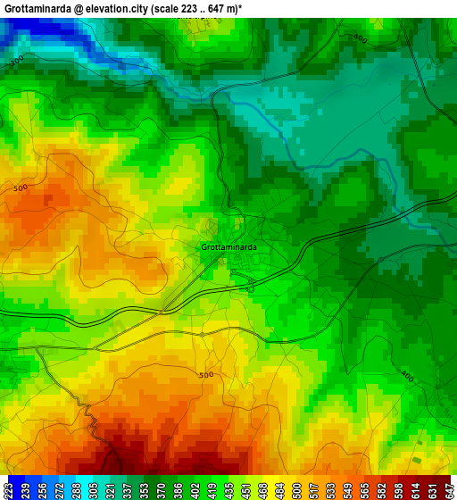
Below is the Elevation map of Grottaminarda, which displays elevation range with different colors. Scale of the first map is from 223 to 647 m (732 to 2123 ft) with average elevation of 426.4 meters (=1399 ft) [note 1]
These maps also provides idea of topography and contour of this city, they are displayed at different zoom levels. More info about maps, scale and edge coordinates you can find below images.
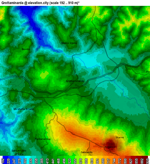
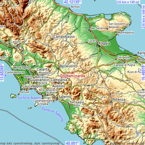
| \ | Map #1 | Map #2 | Topo.Map |
| Scale [m] | 223..647 m | 192..910 m | × |
| Scale [ft] | 732..2123 ft | 630..2986 ft | × |
| Average | 426.4 m = 1399 ft | 448.1 m = 1470 ft | × |
| Width | 7.37 km = 4.6 mi | 14.74 km = 9.2 mi | 235.8 km = 146.5 mi |
| Height | 7.37 km = 4.6 mi | 14.74 km = 9.2 mi | 235.8 km = 146.5 mi |
| ↑Max Latitude | 41.102842° | 41.135948° | 42.12135° |
| Latitude at center | 41.06972° | 41.06972° | 41.06972° |
| ↓Min Latitude | 41.036581° | 41.003425° | 40.001° |
| ← Min Longitude | 15.014995° | 14.971049° | 13.65269° |
| Longitude center | 15.05894° | 15.05894° | 15.05894° |
| →Max Longitude | 15.102885° | 15.146831° | 16.46519° |
Nearby cities:
Cities around Grottaminarda sort by population:
• Mirabella Eclano elevation 388 m
5.6 km,  240°
240°
• Passo di Mirabella-Pianopantano 433 m
3.9 km, 244°
• Fontanarosa 508 m
6.6 km,  209°
209°
• Gesualdo 683 m
7.2 km,  170°
170°
• Taurasi 369 m
10.6 km,  231°
231°
• Sturno 591 m
6.9 km,  139°
139°
• Flumeri 590 m
7.7 km,  84°
84°
• Bonito 495 m
5.8 km,  303°
303°
• Villanova del Battista 690 m
10 km,  56°
56°
• Melito Irpino 460 m
3.8 km,  351°
351°
• Sant'Angelo All'Esca 457 m
8.9 km,  218°
218°
• Frigento 875 m
7.4 km,  152°
152°
Multilingual:
 En español:
Grottaminarda elevación 424 m.
 En France:
Grottaminarda élévation 424 m.
 Auf Deutsch:
Grottaminarda höhe über dem Meeresspiegel ist 424 m.

Sources and notes:
- [note 1] Map square and city borders are not equal. Map elevation data is calculated only from area inside that square.
- [src 1] Elevation data from geonames database provided with same terms of usage.
- [src 2] The elevation map of Grottaminarda is generated using elevation data from NASA's 3 arcsec (90m) resolution SRTM data.
- [src 3] Base (background) map © OpenStreetMap contributors tiles are generated by Geofabrik and OpenTopoMap.
Copyright & License:
This Grottaminarda Elevation Map is licensed under CC BY-SA. You may reuse any part from this page, if you give a proper credit by linking to this URL:
 More info on terms of use page.