Flumeri elevation
Flumeri (Campania, Provincia di Avellino), Italy elevation is 590 meters and Flumeri elevation in feet is 1936 ft above sea level [src 1]. Flumeri is a seat of a third-order administrative division (feature code) with elevation that is 268 meters (879 ft) bigger than average city elevation in Italy.
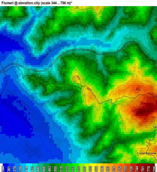
Below is the Elevation map of Flumeri, which displays elevation range with different colors. Scale of the first map is from 344 to 796 m (1129 to 2612 ft) with average elevation of 481 meters (=1578 ft) [note 1]
These maps also provides idea of topography and contour of this city, they are displayed at different zoom levels. More info about maps, scale and edge coordinates you can find below images.
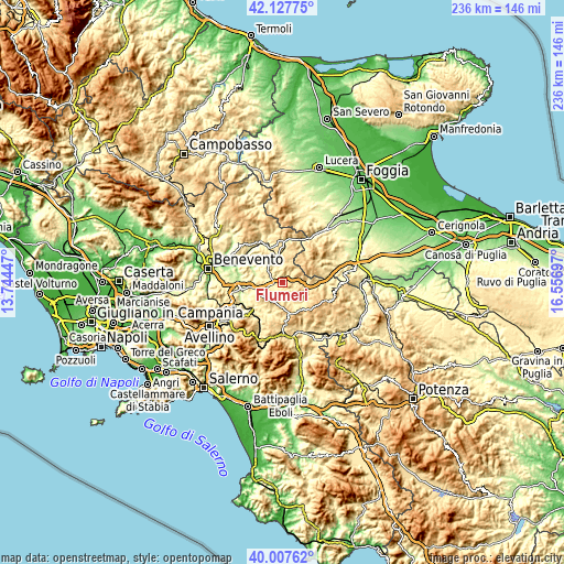
| \ | Map #1 | Topo.Map |
| Scale [m] | 344..796 m | × |
| Scale [ft] | 1129..2612 ft | × |
| Average | 481 m = 1578 ft | × |
| Width | 7.37 km = 4.6 mi | 235.7 km = 146.5 mi |
| Height | 7.37 km = 4.6 mi | 235.7 km = 146.5 mi |
| ↑Max Latitude | 41.109349° | 42.12775° |
| Latitude at center | 41.07623° | 41.07623° |
| ↓Min Latitude | 41.043094° | 40.00762° |
| ← Min Longitude | 15.106775° | 13.74447° |
| Longitude center | 15.15072° | 15.15072° |
| →Max Longitude | 15.194665° | 16.55697° |
Nearby cities:
Cities around Flumeri sort by population:
• Grottaminarda elevation 424 m
7.7 km,  264°
264°
• Sturno 591 m
6.8 km,  208°
208°
• Carife 708 m
7.4 km,  137°
137°
• Villanova del Battista 690 m
4.8 km,  7°
7°
• San Sossio Baronia 638 m
4.3 km,  98°
98°
• Melito Irpino 460 m
8.8 km,  289°
289°
• Castel Baronia 635 m
4.5 km,  134°
134°
• Zungoli 670 m
7.2 km,  37°
37°
• Frigento 875 m
8.4 km, 210°
• San Nicola Baronia 628 m
4.6 km,  116°
116°
• Vallesaccarda 667 m
8.6 km, 99°
• Trevico 1061 m
7.6 km,  114°
114°
Multilingual:
 En español:
Flumeri elevación 590 m.
 En France:
Flumeri élévation 590 m.


Sources and notes:
- [note 1] Map square and city borders are not equal. Map elevation data is calculated only from area inside that square.
- [src 1] Elevation data from geonames database provided with same terms of usage.
- [src 2] The elevation map of Flumeri is generated using elevation data from NASA's 3 arcsec (90m) resolution SRTM data.
- [src 3] Base (background) map © OpenStreetMap contributors tiles are generated by Geofabrik and OpenTopoMap.
Copyright & License:
This Flumeri Elevation Map is licensed under CC BY-SA. You may reuse any part from this page, if you give a proper credit by linking to this URL:
 More info on terms of use page.