Bonito elevation
Bonito (Campania, Provincia di Avellino), Italy elevation is 495 meters and Bonito elevation in feet is 1624 ft above sea level [src 1]. Bonito is a seat of a third-order administrative division (feature code) with elevation that is 173 meters (568 ft) bigger than average city elevation in Italy.
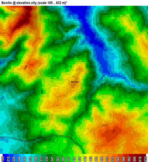
Below is the Elevation map of Bonito, which displays elevation range with different colors. Scale of the first map is from 195 to 633 m (640 to 2077 ft) with average elevation of 390.3 meters (=1281 ft) [note 1]
These maps also provides idea of topography and contour of this city, they are displayed at different zoom levels. More info about maps, scale and edge coordinates you can find below images.
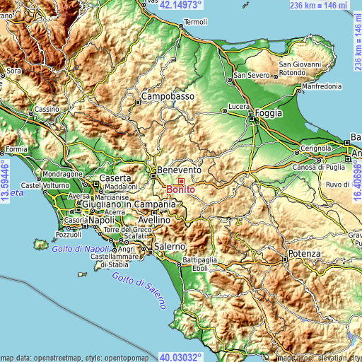
| \ | Map #1 | Topo.Map |
| Scale [m] | 195..633 m | × |
| Scale [ft] | 640..2077 ft | × |
| Average | 390.3 m = 1281 ft | × |
| Width | 7.36 km = 4.6 mi | 235.7 km = 146.5 mi |
| Height | 7.36 km = 4.6 mi | 235.6 km = 146.4 mi |
| ↑Max Latitude | 41.131678° | 42.14973° |
| Latitude at center | 41.09857° | 41.09857° |
| ↓Min Latitude | 41.065445° | 40.03032° |
| ← Min Longitude | 14.956765° | 13.59446° |
| Longitude center | 15.00071° | 15.00071° |
| →Max Longitude | 15.044655° | 16.40696° |
Nearby cities:
Cities around Bonito sort by population:
• Grottaminarda elevation 424 m
5.8 km,  123°
123°
• Venticano 371 m
9.4 km,  232°
232°
• Mirabella Eclano 388 m
6 km,  180°
180°
• Passo di Mirabella-Pianopantano 433 m
5.1 km,  164°
164°
• Montecalvo Irpino 563 m
11.2 km,  14°
14°
• Fontanarosa 508 m
9.1 km,  169°
169°
• Taurasi 369 m
10.3 km,  199°
199°
• Campanarello 362 m
9.2 km, 231°
• Melito Irpino 460 m
4.4 km,  83°
83°
• Sant'Angelo All'Esca 457 m
10.2 km, 183°
• Sant'Arcangelo Trimonte 350 m
9.4 km,  326°
326°
• Apice Vecchio 227 m
6.3 km,  292°
292°
Multilingual:
 En español:
Bonito elevación 495 m.
 En France:
Bonito élévation 495 m.


Sources and notes:
- [note 1] Map square and city borders are not equal. Map elevation data is calculated only from area inside that square.
- [src 1] Elevation data from geonames database provided with same terms of usage.
- [src 2] The elevation map of Bonito is generated using elevation data from NASA's 3 arcsec (90m) resolution SRTM data.
- [src 3] Base (background) map © OpenStreetMap contributors tiles are generated by Geofabrik and OpenTopoMap.
Copyright & License:
This Bonito Elevation Map is licensed under CC BY-SA. You may reuse any part from this page, if you give a proper credit by linking to this URL:
 More info on terms of use page.