Macchia Valfortore elevation
Macchia Valfortore (Molise, Provincia di Campobasso), Italy elevation is 485 meters and Macchia Valfortore elevation in feet is 1591 ft above sea level [src 1]. Macchia Valfortore is a seat of a third-order administrative division (feature code) with elevation that is 163 meters (535 ft) bigger than average city elevation in Italy.
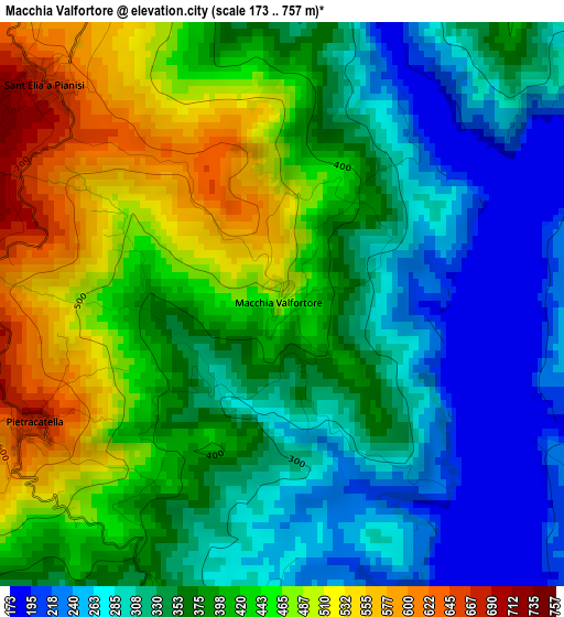
Below is the Elevation map of Macchia Valfortore, which displays elevation range with different colors. Scale of the first map is from 173 to 757 m (568 to 2484 ft) with average elevation of 378.5 meters (=1242 ft) [note 1]
These maps also provides idea of topography and contour of this city, they are displayed at different zoom levels. More info about maps, scale and edge coordinates you can find below images.
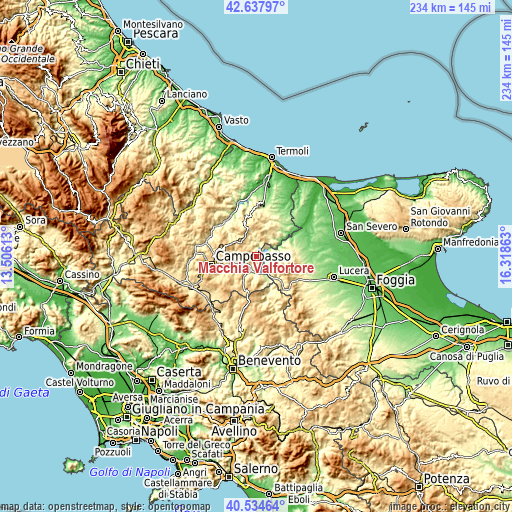
| \ | Map #1 | Topo.Map |
| Scale [m] | 173..757 m | × |
| Scale [ft] | 568..2484 ft | × |
| Average | 378.5 m = 1242 ft | × |
| Width | 7.31 km = 4.5 mi | 233.9 km = 145.3 mi |
| Height | 7.31 km = 4.5 mi | 233.9 km = 145.3 mi |
| ↑Max Latitude | 41.627726° | 42.63797° |
| Latitude at center | 41.59487° | 41.59487° |
| ↓Min Latitude | 41.561997° | 40.53464° |
| ← Min Longitude | 14.868435° | 13.50613° |
| Longitude center | 14.91238° | 14.91238° |
| →Max Longitude | 14.956325° | 16.31863° |
Nearby cities:
Cities around Macchia Valfortore sort by population:
• Colletorto elevation 535 m
8.7 km,  31°
31°
• Celenza Valfortore 463 m
6.7 km,  124°
124°
• Sant'Elia a Pianisi 661 m
4.2 km,  312°
312°
• Bonefro 628 m
12.4 km,  8°
8°
• Pietracatella 679 m
3.6 km,  244°
244°
• Gambatesa 477 m
9.6 km,  179°
179°
• San Marco la Catola 656 m
11 km,  135°
135°
• Toro 573 m
12.8 km,  259°
259°
• Carlantino 546 m
5.4 km,  91°
91°
• San Giuliano di Puglia 472 m
11.2 km,  21°
21°
• Campolieto 730 m
12.8 km,  289°
289°
• Monacilioni 600 m
8.7 km,  281°
281°
Multilingual:
 En español:
Macchia Valfortore elevación 485 m.
 En France:
Macchia Valfortore élévation 485 m.
 Auf Deutsch:
Macchia Valfortore höhe über dem Meeresspiegel ist 485 m.
 На русском:
Macchia Valfortore высота над уровнем моря 485 м
Sources and notes:
- [note 1] Map square and city borders are not equal. Map elevation data is calculated only from area inside that square.
- [src 1] Elevation data from geonames database provided with same terms of usage.
- [src 2] The elevation map of Macchia Valfortore is generated using elevation data from NASA's 3 arcsec (90m) resolution SRTM data.
- [src 3] Base (background) map © OpenStreetMap contributors tiles are generated by Geofabrik and OpenTopoMap.
Copyright & License:
This Macchia Valfortore Elevation Map is licensed under CC BY-SA. You may reuse any part from this page, if you give a proper credit by linking to this URL:
 More info on terms of use page.