Mango elevation
Mango (Piedmont, Provincia di Cuneo), Italy elevation is 493 meters and Mango elevation in feet is 1617 ft above sea level [src 1]. Mango is a seat of a third-order administrative division (feature code) with elevation that is 171 meters (561 ft) bigger than average city elevation in Italy.
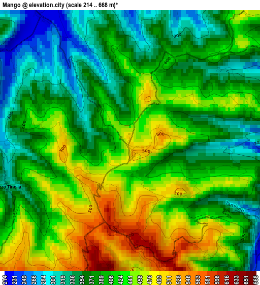
Below is the Elevation map of Mango, which displays elevation range with different colors. Scale of the first map is from 214 to 668 m (702 to 2192 ft) with average elevation of 404 meters (=1325 ft) [note 1]
These maps also provides idea of topography and contour of this city, they are displayed at different zoom levels. More info about maps, scale and edge coordinates you can find below images.
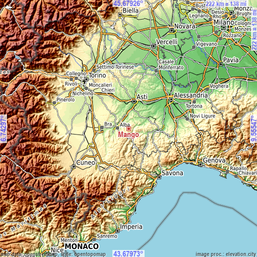
| \ | Map #1 | Topo.Map |
| Scale [m] | 214..668 m | × |
| Scale [ft] | 702..2192 ft | × |
| Average | 404 m = 1325 ft | × |
| Width | 6.95 km = 4.3 mi | 222.3 km = 138.1 mi |
| Height | 6.95 km = 4.3 mi | 222.3 km = 138.1 mi |
| ↑Max Latitude | 44.719354° | 45.67926° |
| Latitude at center | 44.68812° | 44.68812° |
| ↓Min Latitude | 44.656869° | 43.67973° |
| ← Min Longitude | 8.105275° | 6.74297° |
| Longitude center | 8.14922° | 8.14922° |
| →Max Longitude | 8.193165° | 9.55547° |
Nearby cities:
Cities around Mango sort by population:
• Castagnole delle Lanze elevation 202 m
6.9 km,  0°
0°
• Neive-Borgonovo 236 m
4.7 km,  328°
328°
• Cossano Belbo 246 m
4.5 km,  118°
118°
• Treiso 411 m
4.8 km,  272°
272°
• Barbaresco 250 m
6.6 km,  306°
306°
• Castiglione Tinella 400 m
5.3 km,  38°
38°
• Rocchetta Belbo 277 m
6.1 km,  160°
160°
• Coazzolo 275 m
4.5 km,  355°
355°
• Camo 457 m
3.6 km,  77°
77°
• Neviglie 453 m
2.6 km,  279°
279°
• Bricco di Neive 305 m
2.9 km,  335°
335°
• Trezzo Tinella 332 m
3.5 km,  249°
249°
Multilingual:
 En español:
Mango elevación 493 m.
 En France:
Mango élévation 493 m.


Sources and notes:
- [note 1] Map square and city borders are not equal. Map elevation data is calculated only from area inside that square.
- [src 1] Elevation data from geonames database provided with same terms of usage.
- [src 2] The elevation map of Mango is generated using elevation data from NASA's 3 arcsec (90m) resolution SRTM data.
- [src 3] Base (background) map © OpenStreetMap contributors tiles are generated by Geofabrik and OpenTopoMap.
Copyright & License:
This Mango Elevation Map is licensed under CC BY-SA. You may reuse any part from this page, if you give a proper credit by linking to this URL:
 More info on terms of use page.