Rocchetta Belbo elevation
Rocchetta Belbo (Piedmont, Provincia di Cuneo), Italy elevation is 277 meters and Rocchetta Belbo elevation in feet is 909 ft above sea level [src 1]. Rocchetta Belbo is a seat of a third-order administrative division (feature code) with elevation that is 45 meters (148 ft) smaller than average city elevation in Italy.
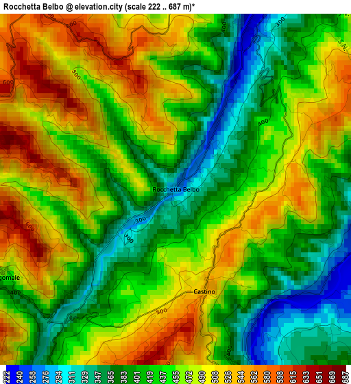
Below is the Elevation map of Rocchetta Belbo, which displays elevation range with different colors. Scale of the first map is from 222 to 687 m (728 to 2254 ft) with average elevation of 449.4 meters (=1474 ft) [note 1]
These maps also provides idea of topography and contour of this city, they are displayed at different zoom levels. More info about maps, scale and edge coordinates you can find below images.
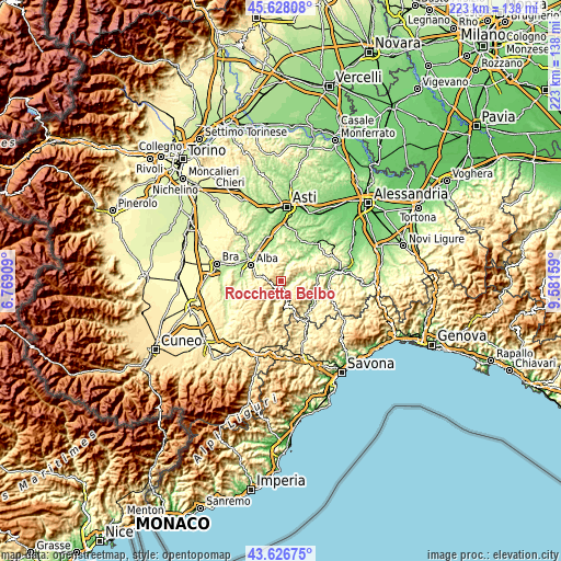
| \ | Map #1 | Topo.Map |
| Scale [m] | 222..687 m | × |
| Scale [ft] | 728..2254 ft | × |
| Average | 449.4 m = 1474 ft | × |
| Width | 6.95 km = 4.3 mi | 222.5 km = 138.3 mi |
| Height | 6.95 km = 4.3 mi | 222.5 km = 138.3 mi |
| ↑Max Latitude | 44.667302° | 45.62808° |
| Latitude at center | 44.63604° | 44.63604° |
| ↓Min Latitude | 44.604761° | 43.62675° |
| ← Min Longitude | 8.131395° | 6.76909° |
| Longitude center | 8.17534° | 8.17534° |
| →Max Longitude | 8.219285° | 9.58159° |
Nearby cities:
Cities around Rocchetta Belbo sort by population:
• Cortemilia elevation 249 m
6.4 km,  166°
166°
• Mango 493 m
6.1 km,  340°
340°
• Cossano Belbo 246 m
4.1 km,  26°
26°
• Vesime 224 m
4.1 km,  91°
91°
• Benevello 655 m
5.6 km,  262°
262°
• Castino 539 m
2.1 km,  164°
164°
• Cessole 236 m
5.6 km,  75°
75°
• Camo 457 m
6.7 km,  12°
12°
• Perletto 453 m
5.1 km,  143°
143°
• Bosia 481 m
4.3 km,  210°
210°
• San Giorgio Scarampi 605 m
6 km,  117°
117°
• Borgomale 454 m
3.8 km,  242°
242°
Multilingual:
 En español:
Rocchetta Belbo elevación 277 m.
 En France:
Rocchetta Belbo élévation 277 m.
 Auf Deutsch:
Rocchetta Belbo höhe über dem Meeresspiegel ist 277 m.

Sources and notes:
- [note 1] Map square and city borders are not equal. Map elevation data is calculated only from area inside that square.
- [src 1] Elevation data from geonames database provided with same terms of usage.
- [src 2] The elevation map of Rocchetta Belbo is generated using elevation data from NASA's 3 arcsec (90m) resolution SRTM data.
- [src 3] Base (background) map © OpenStreetMap contributors tiles are generated by Geofabrik and OpenTopoMap.
Copyright & License:
This Rocchetta Belbo Elevation Map is licensed under CC BY-SA. You may reuse any part from this page, if you give a proper credit by linking to this URL:
 More info on terms of use page.