Masone elevation
Masone (Liguria, Provincia di Genova), Italy elevation is 411 meters and Masone elevation in feet is 1348 ft above sea level [src 1]. Masone is a seat of a third-order administrative division (feature code) with elevation that is 89 meters (292 ft) bigger than average city elevation in Italy.
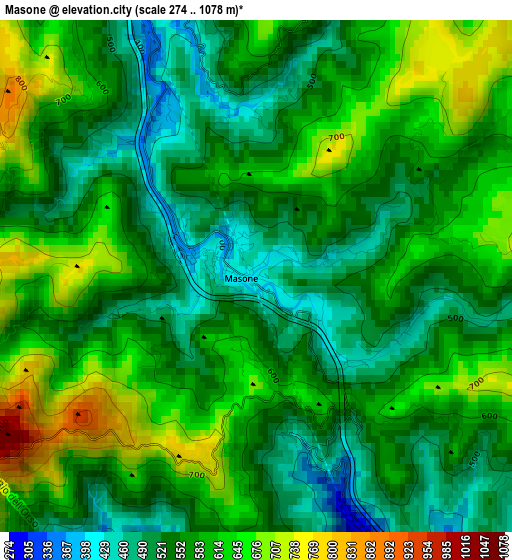
Below is the Elevation map of Masone, which displays elevation range with different colors. Scale of the first map is from 274 to 1078 m (899 to 3537 ft) with average elevation of 574.2 meters (=1884 ft) [note 1]
These maps also provides idea of topography and contour of this city, they are displayed at different zoom levels. More info about maps, scale and edge coordinates you can find below images.
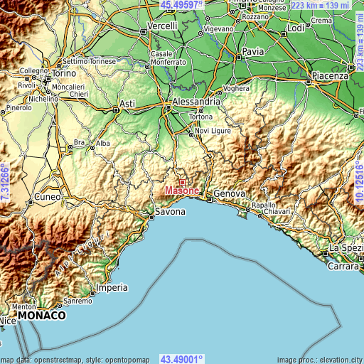
| \ | Map #1 | Topo.Map |
| Scale [m] | 274..1078 m | × |
| Scale [ft] | 899..3537 ft | × |
| Average | 574.2 m = 1884 ft | × |
| Width | 6.97 km = 4.3 mi | 223 km = 138.6 mi |
| Height | 6.97 km = 4.3 mi | 223 km = 138.6 mi |
| ↑Max Latitude | 44.532955° | 45.49597° |
| Latitude at center | 44.50162° | 44.50162° |
| ↓Min Latitude | 44.470268° | 43.49001° |
| ← Min Longitude | 8.674965° | 7.31266° |
| Longitude center | 8.71891° | 8.71891° |
| →Max Longitude | 8.762855° | 10.12516° |
Nearby cities:
Cities around Masone sort by population:
• Arenzano elevation 24 m
11.1 km,  194°
194°
• Cogoleto 11 m
13.7 km,  204°
204°
• Campomorone 134 m
13.2 km,  86°
86°
• Ceranesi 120 m
13.8 km, 88°
• Campo Ligure 355 m
4.2 km,  337°
337°
• Rossiglione 297 m
7.9 km,  330°
330°
• Mele 126 m
6.7 km,  159°
159°
• Isoverde 235 m
11.6 km,  74°
74°
• Urbe 562 m
10.7 km,  261°
261°
• Tiglieto 495 m
8.3 km,  286°
286°
• Casavecchia 531 m
8.2 km, 290°
• San Pietro d'Olba 537 m
10.4 km, 261°
Multilingual:
 En español:
Masone elevación 411 m.
 En France:
Masone élévation 411 m.


Sources and notes:
- [note 1] Map square and city borders are not equal. Map elevation data is calculated only from area inside that square.
- [src 1] Elevation data from geonames database provided with same terms of usage.
- [src 2] The elevation map of Masone is generated using elevation data from NASA's 3 arcsec (90m) resolution SRTM data.
- [src 3] Base (background) map © OpenStreetMap contributors tiles are generated by Geofabrik and OpenTopoMap.
Copyright & License:
This Masone Elevation Map is licensed under CC BY-SA. You may reuse any part from this page, if you give a proper credit by linking to this URL:
 More info on terms of use page.