Rossiglione elevation
Rossiglione (Liguria, Provincia di Genova), Italy elevation is 297 meters and Rossiglione elevation in feet is 974 ft above sea level [src 1]. Rossiglione is a seat of a third-order administrative division (feature code) with elevation that is 25 meters (82 ft) smaller than average city elevation in Italy.
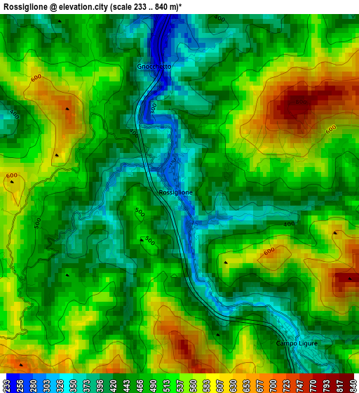
Below is the Elevation map of Rossiglione, which displays elevation range with different colors. Scale of the first map is from 233 to 840 m (764 to 2756 ft) with average elevation of 490.1 meters (=1608 ft) [note 1]
These maps also provides idea of topography and contour of this city, they are displayed at different zoom levels. More info about maps, scale and edge coordinates you can find below images.
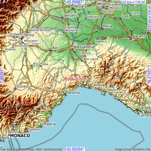
| \ | Map #1 | Topo.Map |
| Scale [m] | 233..840 m | × |
| Scale [ft] | 764..2756 ft | × |
| Average | 490.1 m = 1608 ft | × |
| Width | 6.96 km = 4.3 mi | 222.8 km = 138.4 mi |
| Height | 6.96 km = 4.3 mi | 222.8 km = 138.4 mi |
| ↑Max Latitude | 44.594881° | 45.55687° |
| Latitude at center | 44.56358° | 44.56358° |
| ↓Min Latitude | 44.532262° | 43.55304° |
| ← Min Longitude | 8.625615° | 7.26331° |
| Longitude center | 8.66956° | 8.66956° |
| →Max Longitude | 8.713505° | 10.07581° |
Nearby cities:
Cities around Rossiglione sort by population:
• Ovada elevation 192 m
8.5 km,  345°
345°
• Masone 411 m
7.9 km,  150°
150°
• Campo Ligure 355 m
3.8 km,  142°
142°
• Molare 226 m
8.2 km,  317°
317°
• Tagliolo Monferrato 284 m
8.3 km,  357°
357°
• Lerma 289 m
8.7 km,  23°
23°
• Tiglieto 495 m
6 km,  221°
221°
• Belforte Monferrato 257 m
6.9 km, 354°
• Cassinelle-Concentrico 373 m
9.4 km,  296°
296°
• Casavecchia 531 m
5.5 km, 223°
• Cremolino 414 m
10.5 km, 320°
• Casaleggio Boiro 319 m
9.2 km,  31°
31°
Multilingual:
 En español:
Rossiglione elevación 297 m.
 En France:
Rossiglione élévation 297 m.
 Auf Deutsch:
Rossiglione höhe über dem Meeresspiegel ist 297 m.

Sources and notes:
- [note 1] Map square and city borders are not equal. Map elevation data is calculated only from area inside that square.
- [src 1] Elevation data from geonames database provided with same terms of usage.
- [src 2] The elevation map of Rossiglione is generated using elevation data from NASA's 3 arcsec (90m) resolution SRTM data.
- [src 3] Base (background) map © OpenStreetMap contributors tiles are generated by Geofabrik and OpenTopoMap.
Copyright & License:
This Rossiglione Elevation Map is licensed under CC BY-SA. You may reuse any part from this page, if you give a proper credit by linking to this URL:
 More info on terms of use page.