Campomorone elevation
Campomorone (Liguria, Provincia di Genova), Italy elevation is 134 meters and Campomorone elevation in feet is 440 ft above sea level [src 1]. Campomorone is a seat of a third-order administrative division (feature code) with elevation that is 188 meters (617 ft) smaller than average city elevation in Italy.
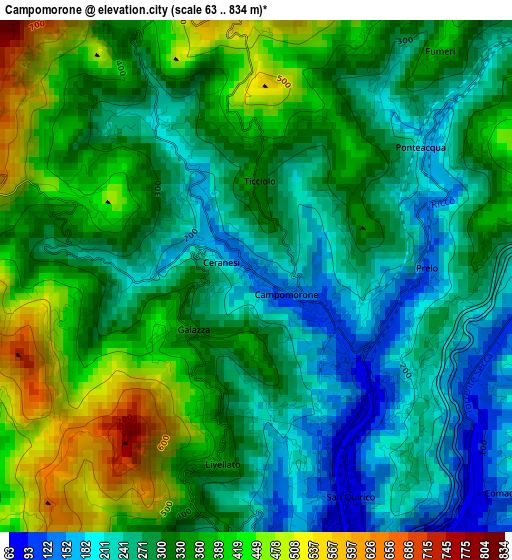
Below is the Elevation map of Campomorone, which displays elevation range with different colors. Scale of the first map is from 63 to 834 m (207 to 2736 ft) with average elevation of 317 meters (=1040 ft) [note 1]
These maps also provides idea of topography and contour of this city, they are displayed at different zoom levels. More info about maps, scale and edge coordinates you can find below images.
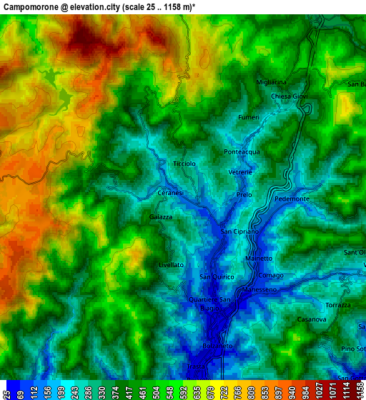
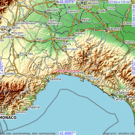
| \ | Map #1 | Map #2 | Topo.Map |
| Scale [m] | 63..834 m | 25..1158 m | × |
| Scale [ft] | 207..2736 ft | 82..3799 ft | × |
| Average | 317 m = 1040 ft | 453.1 m = 1487 ft | × |
| Width | 6.97 km = 4.3 mi | 13.94 km = 8.7 mi | 223 km = 138.6 mi |
| Height | 6.97 km = 4.3 mi | 13.94 km = 8.7 mi | 223 km = 138.6 mi |
| ↑Max Latitude | 44.54087° | 44.572184° | 45.50376° |
| Latitude at center | 44.50954° | 44.50954° | 44.50954° |
| ↓Min Latitude | 44.478193° | 44.446829° | 43.49807° |
| ← Min Longitude | 8.841075° | 8.797129° | 7.47877° |
| Longitude center | 8.88502° | 8.88502° | 8.88502° |
| →Max Longitude | 8.928965° | 8.972911° | 10.29127° |
Nearby cities:
Cities around Campomorone sort by population:
• Serra Riccò elevation 145 m
4.2 km,  88°
88°
• Pedemonte 128 m
3.3 km,  102°
102°
• Busalla 373 m
8.3 km,  35°
35°
• Ceranesi 120 m
0.8 km,  123°
123°
• Casella 412 m
9.6 km,  72°
72°
• Manesseno 122 m
4.9 km,  135°
135°
• Mignanego 176 m
3 km,  49°
49°
• Borgo Fornari-Pieve 355 m
9.8 km,  24°
24°
• Isoverde 235 m
2.9 km,  318°
318°
• Piccarello 173 m
7 km,  113°
113°
• Santa Marta 120 m
0.9 km, 135°
• Fraconalto 724 m
9.1 km,  356°
356°
Multilingual:
 En español:
Campomorone elevación 134 m.
 En France:
Campomorone élévation 134 m.
 Auf Deutsch:
Campomorone höhe über dem Meeresspiegel ist 134 m.

Sources and notes:
- [note 1] Map square and city borders are not equal. Map elevation data is calculated only from area inside that square.
- [src 1] Elevation data from geonames database provided with same terms of usage.
- [src 2] The elevation map of Campomorone is generated using elevation data from NASA's 3 arcsec (90m) resolution SRTM data.
- [src 3] Base (background) map © OpenStreetMap contributors tiles are generated by Geofabrik and OpenTopoMap.
Copyright & License:
This Campomorone Elevation Map is licensed under CC BY-SA. You may reuse any part from this page, if you give a proper credit by linking to this URL:
 More info on terms of use page.