Casella elevation
Casella (Liguria, Provincia di Genova), Italy elevation is 412 meters and Casella elevation in feet is 1352 ft above sea level [src 1]. Casella is a seat of a third-order administrative division (feature code) with elevation that is 90 meters (295 ft) bigger than average city elevation in Italy.
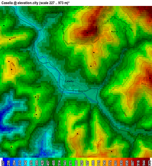
Below is the Elevation map of Casella, which displays elevation range with different colors. Scale of the first map is from 227 to 973 m (745 to 3192 ft) with average elevation of 547.4 meters (=1796 ft) [note 1]
These maps also provides idea of topography and contour of this city, they are displayed at different zoom levels. More info about maps, scale and edge coordinates you can find below images.
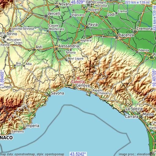
| \ | Map #1 | Topo.Map |
| Scale [m] | 227..973 m | × |
| Scale [ft] | 745..3192 ft | × |
| Average | 547.4 m = 1796 ft | × |
| Width | 6.97 km = 4.3 mi | 222.9 km = 138.5 mi |
| Height | 6.97 km = 4.3 mi | 222.9 km = 138.5 mi |
| ↑Max Latitude | 44.566547° | 45.529° |
| Latitude at center | 44.53523° | 44.53523° |
| ↓Min Latitude | 44.503897° | 43.5242° |
| ← Min Longitude | 8.956855° | 7.59455° |
| Longitude center | 9.0008° | 9.0008° |
| →Max Longitude | 9.044745° | 10.40705° |
Nearby cities:
Cities around Casella sort by population:
• Serra Riccò elevation 145 m
5.7 km,  241°
241°
• Pedemonte 128 m
6.9 km, 238°
• Busalla 373 m
5.9 km,  311°
311°
• Manesseno 122 m
8.6 km,  222°
222°
• Mignanego 176 m
6.9 km,  262°
262°
• Montoggio 443 m
4.3 km,  117°
117°
• Savignone 474 m
3.4 km,  341°
341°
• Borgo Fornari-Pieve 355 m
7.9 km,  319°
319°
• Crocefieschi 751 m
5.4 km,  19°
19°
• Piccarello 173 m
6.3 km,  205°
205°
• Vobbia 455 m
7.9 km, 22°
• Molino Vecchio-Scapitola-Baio 563 m
5.8 km,  67°
67°
Multilingual:
 En español:
Casella elevación 412 m.
 En France:
Casella élévation 412 m.


Sources and notes:
- [note 1] Map square and city borders are not equal. Map elevation data is calculated only from area inside that square.
- [src 1] Elevation data from geonames database provided with same terms of usage.
- [src 2] The elevation map of Casella is generated using elevation data from NASA's 3 arcsec (90m) resolution SRTM data.
- [src 3] Base (background) map © OpenStreetMap contributors tiles are generated by Geofabrik and OpenTopoMap.
Copyright & License:
This Casella Elevation Map is licensed under CC BY-SA. You may reuse any part from this page, if you give a proper credit by linking to this URL:
 More info on terms of use page.