Meda elevation
Meda (Lombardy, Provincia di Monza e della Brianza), Italy elevation is 221 meters and Meda elevation in feet is 725 ft above sea level [src 1]. Meda is a seat of a third-order administrative division (feature code) with elevation that is 101 meters (331 ft) smaller than average city elevation in Italy.
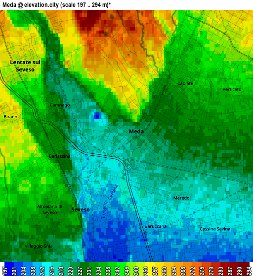
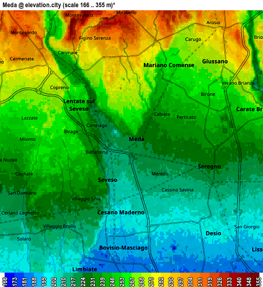
Below is the Elevation map of Meda, which displays elevation range with different colors. Scale of the first map is from 197 to 294 m (646 to 965 ft) with average elevation of 233.2 meters (=765 ft) [note 1]
These maps also provides idea of topography and contour of this city, they are displayed at different zoom levels. More info about maps, scale and edge coordinates you can find below images.
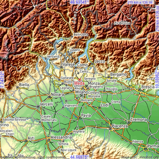
| \ | Map #1 | Map #2 | Topo.Map |
| Scale [m] | 197..294 m | 166..355 m | × |
| Scale [ft] | 646..965 ft | 545..1165 ft | × |
| Average | 233.2 m = 765 ft | 240.3 m = 788 ft | × |
| Width | 6.83 km = 4.2 mi | 13.66 km = 8.5 mi | 218.6 km = 135.8 mi |
| Height | 6.83 km = 4.2 mi | 13.66 km = 8.5 mi | 218.5 km = 135.8 mi |
| ↑Max Latitude | 45.691915° | 45.722603° | 46.63541° |
| Latitude at center | 45.66121° | 45.66121° | 45.66121° |
| ↓Min Latitude | 45.630488° | 45.59975° | 44.66975° |
| ← Min Longitude | 9.109425° | 9.065479° | 7.74712° |
| Longitude center | 9.15337° | 9.15337° | 9.15337° |
| →Max Longitude | 9.197315° | 9.241261° | 10.55962° |
Nearby cities:
Cities around Meda sort by population:
• Seregno elevation 229 m
4.2 km,  107°
107°
• Cesano Maderno 202 m
3.6 km,  181°
181°
• Seveso 211 m
1.8 km,  206°
206°
• Mariano Comense 254 m
4.5 km,  29°
29°
• Bovisio-Masciago 190 m
5.7 km, 180°
• Lentate sul Seveso 248 m
3.2 km,  301°
301°
• Lazzate 259 m
5.5 km,  282°
282°
• Cabiate 236 m
2.1 km,  47°
47°
• Barlassina 231 m
2 km,  251°
251°
• Figino Serenza 310 m
5.7 km,  342°
342°
• Misinto 247 m
5.6 km,  270°
270°
• Novedrate 279 m
4.8 km,  328°
328°
Multilingual:
 En español:
Meda elevación 221 m.
 En France:
Meda élévation 221 m.


Sources and notes:
- [note 1] Map square and city borders are not equal. Map elevation data is calculated only from area inside that square.
- [src 1] Elevation data from geonames database provided with same terms of usage.
- [src 2] The elevation map of Meda is generated using elevation data from NASA's 3 arcsec (90m) resolution SRTM data.
- [src 3] Base (background) map © OpenStreetMap contributors tiles are generated by Geofabrik and OpenTopoMap.
Copyright & License:
This Meda Elevation Map is licensed under CC BY-SA. You may reuse any part from this page, if you give a proper credit by linking to this URL:
 More info on terms of use page.