Novedrate elevation
Novedrate (Lombardy, Provincia di Como), Italy elevation is 279 meters and Novedrate elevation in feet is 915 ft above sea level [src 1]. Novedrate is a seat of a third-order administrative division (feature code) with elevation that is 43 meters (141 ft) smaller than average city elevation in Italy.
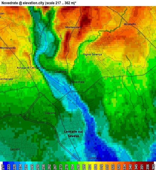
Below is the Elevation map of Novedrate, which displays elevation range with different colors. Scale of the first map is from 217 to 362 m (712 to 1188 ft) with average elevation of 281.7 meters (=924 ft) [note 1]
These maps also provides idea of topography and contour of this city, they are displayed at different zoom levels. More info about maps, scale and edge coordinates you can find below images.
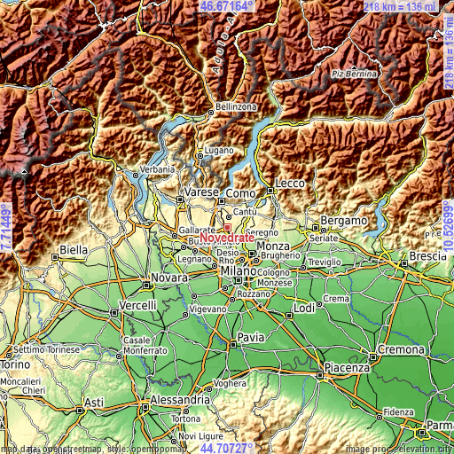
| \ | Map #1 | Topo.Map |
| Scale [m] | 217..362 m | × |
| Scale [ft] | 712..1188 ft | × |
| Average | 281.7 m = 924 ft | × |
| Width | 6.83 km = 4.2 mi | 218.4 km = 135.7 mi |
| Height | 6.83 km = 4.2 mi | 218.4 km = 135.7 mi |
| ↑Max Latitude | 45.728765° | 46.67164° |
| Latitude at center | 45.69808° | 45.69808° |
| ↓Min Latitude | 45.667378° | 44.70727° |
| ← Min Longitude | 9.076795° | 7.71449° |
| Longitude center | 9.12074° | 9.12074° |
| →Max Longitude | 9.164685° | 10.52699° |
Nearby cities:
Cities around Novedrate sort by population:
• Cantù elevation 362 m
4.8 km,  9°
9°
• Meda 221 m
4.8 km,  148°
148°
• Mariano Comense 254 m
4.7 km,  92°
92°
• Lentate sul Seveso 248 m
2.4 km,  185°
185°
• Cermenate 303 m
2.9 km,  278°
278°
• Lazzate 259 m
4 km,  224°
224°
• Barlassina 231 m
4.8 km,  172°
172°
• Bregnano 297 m
4.8 km,  269°
269°
• San Michele-San Giorgio 285 m
4.8 km, 267°
• Figino Serenza 310 m
1.6 km,  30°
30°
• Carimate 294 m
1.4 km,  312°
312°
• Montesolaro 316 m
2.6 km,  354°
354°
Multilingual:
 En español:
Novedrate elevación 279 m.
 En France:
Novedrate élévation 279 m.
 Auf Deutsch:
Novedrate höhe über dem Meeresspiegel ist 279 m.

Sources and notes:
- [note 1] Map square and city borders are not equal. Map elevation data is calculated only from area inside that square.
- [src 1] Elevation data from geonames database provided with same terms of usage.
- [src 2] The elevation map of Novedrate is generated using elevation data from NASA's 3 arcsec (90m) resolution SRTM data.
- [src 3] Base (background) map © OpenStreetMap contributors tiles are generated by Geofabrik and OpenTopoMap.
Copyright & License:
This Novedrate Elevation Map is licensed under CC BY-SA. You may reuse any part from this page, if you give a proper credit by linking to this URL:
 More info on terms of use page.