Miranda elevation
Miranda (Molise, Provincia di Isernia), Italy elevation is 887 meters and Miranda elevation in feet is 2910 ft above sea level [src 1]. Miranda is a seat of a third-order administrative division (feature code) with elevation that is 565 meters (1854 ft) bigger than average city elevation in Italy.
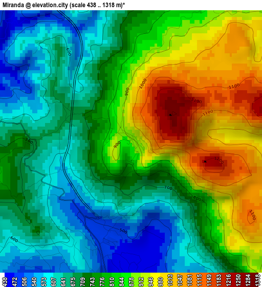
Below is the Elevation map of Miranda, which displays elevation range with different colors. Scale of the first map is from 438 to 1318 m (1437 to 4324 ft) with average elevation of 777.5 meters (=2551 ft) [note 1]
These maps also provides idea of topography and contour of this city, they are displayed at different zoom levels. More info about maps, scale and edge coordinates you can find below images.
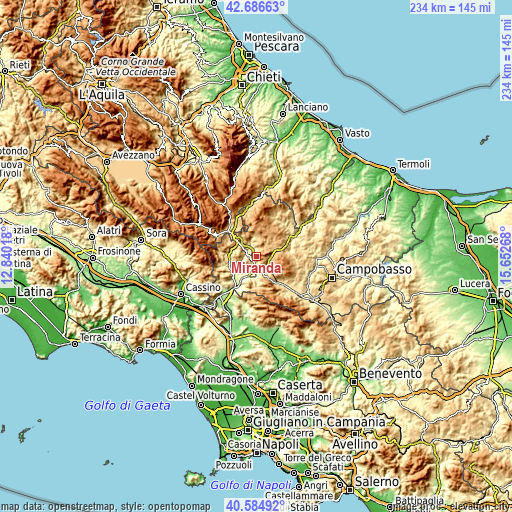
| \ | Map #1 | Topo.Map |
| Scale [m] | 438..1318 m | × |
| Scale [ft] | 1437..4324 ft | × |
| Average | 777.5 m = 2551 ft | × |
| Width | 7.3 km = 4.5 mi | 233.7 km = 145.2 mi |
| Height | 7.3 km = 4.5 mi | 233.7 km = 145.2 mi |
| ↑Max Latitude | 41.677171° | 42.68663° |
| Latitude at center | 41.64434° | 41.64434° |
| ↓Min Latitude | 41.611492° | 40.58492° |
| ← Min Longitude | 14.202485° | 12.84018° |
| Longitude center | 14.24643° | 14.24643° |
| →Max Longitude | 14.290375° | 15.65268° |
Nearby cities:
Cities around Miranda sort by population:
• Isernia elevation 479 m
5.5 km,  190°
190°
• Pesche 566 m
5 km,  150°
150°
• Carpinone 655 m
8.9 km,  132°
132°
• Carovilli 884 m
8.6 km,  27°
27°
• Pescolanciano 808 m
8.5 km,  62°
62°
• Macchia d'Isernia 316 m
11.3 km,  214°
214°
• Sessano del Molise 740 m
6.8 km,  94°
94°
• Fornelli 522 m
9.8 km,  244°
244°
• Roccasicura 726 m
6 km,  347°
347°
• Forlì del Sannio 625 m
8 km,  315°
315°
• Acquaviva d'Isernia 719 m
8.7 km,  290°
290°
• Pettoranello del Molise 727 m
8.3 km,  161°
161°
Multilingual:
 En español:
Miranda elevación 887 m.
 En France:
Miranda élévation 887 m.


Sources and notes:
- [note 1] Map square and city borders are not equal. Map elevation data is calculated only from area inside that square.
- [src 1] Elevation data from geonames database provided with same terms of usage.
- [src 2] The elevation map of Miranda is generated using elevation data from NASA's 3 arcsec (90m) resolution SRTM data.
- [src 3] Base (background) map © OpenStreetMap contributors tiles are generated by Geofabrik and OpenTopoMap.
Copyright & License:
This Miranda Elevation Map is licensed under CC BY-SA. You may reuse any part from this page, if you give a proper credit by linking to this URL:
 More info on terms of use page.