Pescolanciano elevation
Pescolanciano (Molise, Provincia di Isernia), Italy elevation is 808 meters and Pescolanciano elevation in feet is 2651 ft above sea level [src 1]. Pescolanciano is a seat of a third-order administrative division (feature code) with elevation that is 486 meters (1594 ft) bigger than average city elevation in Italy.
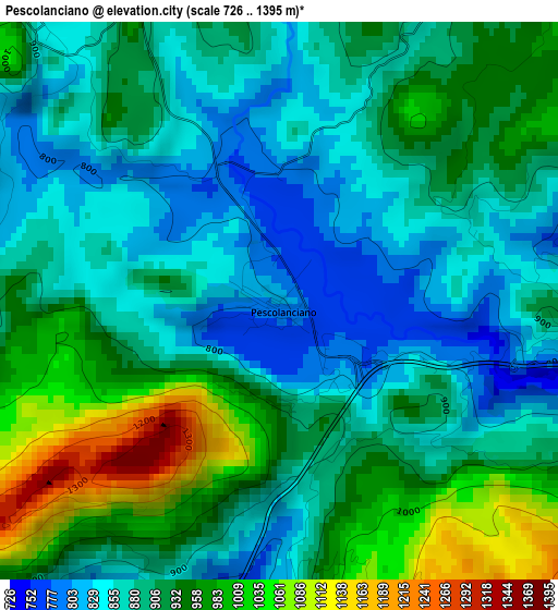
Below is the Elevation map of Pescolanciano, which displays elevation range with different colors. Scale of the first map is from 726 to 1395 m (2382 to 4577 ft) with average elevation of 909.6 meters (=2984 ft) [note 1]
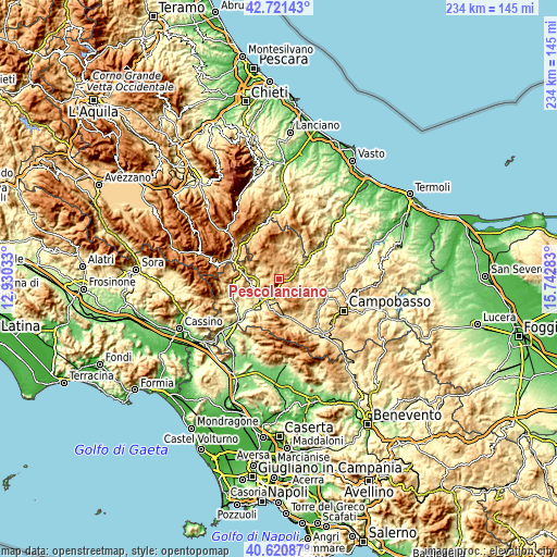
These maps also provides idea of topography and contour of this city, they are displayed at different zoom levels. More info about maps, scale and edge coordinates you can find below images.
| \ | Map #1 | Topo.Map |
| Scale [m] | 726..1395 m | × |
| Scale [ft] | 2382..4577 ft | × |
| Average | 909.6 m = 2984 ft | × |
| Width | 7.3 km = 4.5 mi | 233.6 km = 145.2 mi |
| Height | 7.3 km = 4.5 mi | 233.6 km = 145.2 mi |
| ↑Max Latitude | 41.712533° | 42.72143° |
| Latitude at center | 41.67972° | 41.67972° |
| ↓Min Latitude | 41.64689° | 40.62087° |
| ← Min Longitude | 14.292635° | 12.93033° |
| Longitude center | 14.33658° | 14.33658° |
| →Max Longitude | 14.380525° | 15.74283° |
Nearby cities:
Cities around Pescolanciano sort by population:
• Pesche elevation 566 m
9.7 km,  211°
211°
• Carpinone 655 m
10 km,  185°
185°
• Miranda 887 m
8.5 km,  242°
242°
• Carovilli 884 m
5.2 km,  316°
316°
• Sessano del Molise 740 m
4.6 km, 189°
• Civitanova del Sannio 657 m
5.6 km,  103°
103°
• Bagnoli del Trigno 629 m
10.4 km,  76°
76°
• Pietrabbondante 983 m
8.3 km,  28°
28°
• Roccasicura 726 m
9 km,  282°
282°
• Duronia 864 m
10.5 km, 103°
• Chiauci 876 m
3.9 km,  92°
92°
• Castelverrino 629 m
11 km, 27°
Multilingual:
 En español:
Pescolanciano elevación 808 m.
 En France:
Pescolanciano élévation 808 m.
 Auf Deutsch:
Pescolanciano höhe über dem Meeresspiegel ist 808 m.

Sources and notes:
- [note 1] Map square and city borders are not equal. Map elevation data is calculated only from area inside that square.
- [src 1] Elevation data from geonames database provided with same terms of usage.
- [src 2] The elevation map of Pescolanciano is generated using elevation data from NASA's 3 arcsec (90m) resolution SRTM data.
- [src 3] Base (background) map © OpenStreetMap contributors tiles are generated by Geofabrik and OpenTopoMap.
Copyright & License:
This Pescolanciano Elevation Map is licensed under CC BY-SA. You may reuse any part from this page, if you give a proper credit by linking to this URL:
 More info on terms of use page.