Monghidoro elevation
Monghidoro (Emilia-Romagna, Bologna), Italy elevation is 840 meters and Monghidoro elevation in feet is 2756 ft above sea level [src 1]. Monghidoro is a seat of a third-order administrative division (feature code) with elevation that is 518 meters (1699 ft) bigger than average city elevation in Italy.
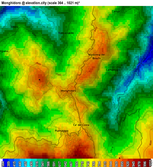
Below is the Elevation map of Monghidoro, which displays elevation range with different colors. Scale of the first map is from 364 to 1021 m (1194 to 3350 ft) with average elevation of 682.3 meters (=2239 ft) [note 1]
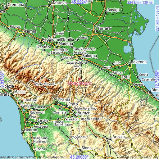
These maps also provides idea of topography and contour of this city, they are displayed at different zoom levels. More info about maps, scale and edge coordinates you can find below images.
| \ | Map #1 | Topo.Map |
| Scale [m] | 364..1021 m | × |
| Scale [ft] | 1194..3350 ft | × |
| Average | 682.3 m = 2239 ft | × |
| Width | 7 km = 4.3 mi | 224.1 km = 139.2 mi |
| Height | 7 km = 4.3 mi | 224.1 km = 139.2 mi |
| ↑Max Latitude | 44.254754° | 45.2224° |
| Latitude at center | 44.22327° | 44.22327° |
| ↓Min Latitude | 44.191769° | 43.20689° |
| ← Min Longitude | 11.279365° | 9.91706° |
| Longitude center | 11.32331° | 11.32331° |
| →Max Longitude | 11.367255° | 12.72956° |
Nearby cities:
Cities around Monghidoro sort by population:
• Grizzana Morandi elevation 554 m
14.1 km,  285°
285°
• Castiglione dei Pepoli 703 m
15.8 km,  235°
235°
• Loiano 687 m
5 km,  4°
4°
• Pizzano 178 m
16.4 km,  26°
26°
• Vado 179 m
11.6 km,  333°
333°
• Firenzuola 426 m
12.4 km,  157°
157°
• Marzabotto 149 m
16.3 km,  324°
324°
• Monzuno 638 m
7.6 km, 323°
• Monterenzio 206 m
13.2 km, 29°
• Castel del Rio 222 m
14.4 km,  94°
94°
• San Benedetto Val di Sambro 635 m
7.1 km,  261°
261°
• Grizzana 557 m
13.9 km, 286°
Multilingual:
 En español:
Monghidoro elevación 840 m.
 En France:
Monghidoro élévation 840 m.
 Auf Deutsch:
Monghidoro höhe über dem Meeresspiegel ist 840 m.

Sources and notes:
- [note 1] Map square and city borders are not equal. Map elevation data is calculated only from area inside that square.
- [src 1] Elevation data from geonames database provided with same terms of usage.
- [src 2] The elevation map of Monghidoro is generated using elevation data from NASA's 3 arcsec (90m) resolution SRTM data.
- [src 3] Base (background) map © OpenStreetMap contributors tiles are generated by Geofabrik and OpenTopoMap.
Copyright & License:
This Monghidoro Elevation Map is licensed under CC BY-SA. You may reuse any part from this page, if you give a proper credit by linking to this URL:
 More info on terms of use page.