Pizzano elevation
Pizzano (Emilia-Romagna, Bologna), Italy elevation is 178 meters and Pizzano elevation in feet is 584 ft above sea level [src 1]. Pizzano is a populated place (feature code) with elevation that is 144 meters (472 ft) smaller than average city elevation in Italy.
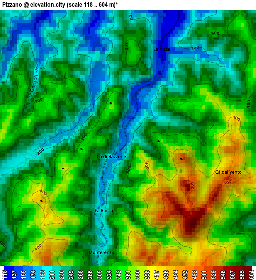
Below is the Elevation map of Pizzano, which displays elevation range with different colors. Scale of the first map is from 118 to 604 m (387 to 1982 ft) with average elevation of 299.6 meters (=983 ft) [note 1]
These maps also provides idea of topography and contour of this city, they are displayed at different zoom levels. More info about maps, scale and edge coordinates you can find below images.
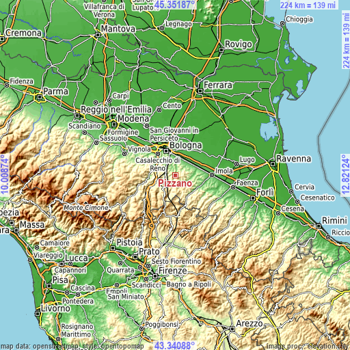
| \ | Map #1 | Topo.Map |
| Scale [m] | 118..604 m | × |
| Scale [ft] | 387..1982 ft | × |
| Average | 299.6 m = 983 ft | × |
| Width | 6.99 km = 4.3 mi | 223.6 km = 138.9 mi |
| Height | 6.99 km = 4.3 mi | 223.6 km = 138.9 mi |
| ↑Max Latitude | 44.386413° | 45.35187° |
| Latitude at center | 44.355° | 44.355° |
| ↓Min Latitude | 44.32357° | 43.34088° |
| ← Min Longitude | 11.371045° | 10.00874° |
| Longitude center | 11.41499° | 11.41499° |
| →Max Longitude | 11.458935° | 12.82124° |
Nearby cities:
Cities around Pizzano sort by population:
• San Lazzaro elevation 66 m
12.9 km,  357°
357°
• Castel San Pietro Terme 80 m
14.4 km,  70°
70°
• Ozzano dell'Emilia 61 m
11 km,  25°
25°
• Pianoro 186 m
6.9 km,  303°
303°
• Sasso Marconi 120 m
13.9 km,  291°
291°
• Rastignano-Carteria di Sesto 117 m
10.1 km,  332°
332°
• Osteria Grande 70 m
11.8 km,  46°
46°
• Ponticella 132 m
11.4 km,  345°
345°
• Loiano 687 m
11.9 km,  215°
215°
• Vado 179 m
13.1 km,  251°
251°
• Pulce 88 m
10.5 km, 358°
• Monterenzio 206 m
3.3 km,  194°
194°
Multilingual:
 En español:
Pizzano elevación 178 m.
 En France:
Pizzano élévation 178 m.


Sources and notes:
- [note 1] Map square and city borders are not equal. Map elevation data is calculated only from area inside that square.
- [src 1] Elevation data from geonames database provided with same terms of usage.
- [src 2] The elevation map of Pizzano is generated using elevation data from NASA's 3 arcsec (90m) resolution SRTM data.
- [src 3] Base (background) map © OpenStreetMap contributors tiles are generated by Geofabrik and OpenTopoMap.
Copyright & License:
This Pizzano Elevation Map is licensed under CC BY-SA. You may reuse any part from this page, if you give a proper credit by linking to this URL:
 More info on terms of use page.