Montecchio elevation
Montecchio (Umbria, Provincia di Terni), Italy elevation is 375 meters and Montecchio elevation in feet is 1230 ft above sea level [src 1]. Montecchio is a seat of a third-order administrative division (feature code) with elevation that is 53 meters (174 ft) bigger than average city elevation in Italy.
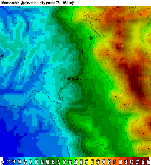
Below is the Elevation map of Montecchio, which displays elevation range with different colors. Scale of the first map is from 78 to 981 m (256 to 3219 ft) with average elevation of 405.4 meters (=1330 ft) [note 1]
These maps also provides idea of topography and contour of this city, they are displayed at different zoom levels. More info about maps, scale and edge coordinates you can find below images.
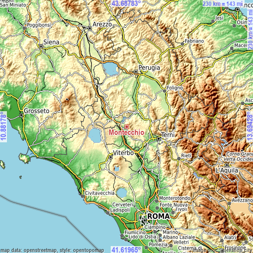
| \ | Map #1 | Topo.Map |
| Scale [m] | 78..981 m | × |
| Scale [ft] | 256..3219 ft | × |
| Average | 405.4 m = 1330 ft | × |
| Width | 7.19 km = 4.5 mi | 230 km = 142.9 mi |
| Height | 7.19 km = 4.5 mi | 230 km = 142.9 mi |
| ↑Max Latitude | 42.694647° | 43.68783° |
| Latitude at center | 42.66234° | 42.66234° |
| ↓Min Latitude | 42.630016° | 41.61965° |
| ← Min Longitude | 12.244085° | 10.88178° |
| Longitude center | 12.28803° | 12.28803° |
| →Max Longitude | 12.331975° | 13.69428° |
Nearby cities:
Cities around Montecchio sort by population:
• Ciconia elevation 124 m
14.9 km,  302°
302°
• Orvieto Scalo 118 m
14.2 km, 297°
• Castiglione in Teverina 254 m
7.1 km,  259°
259°
• Porano 439 m
15.2 km,  277°
277°
• Avigliano Umbro 420 m
11.3 km,  95°
95°
• Guardea 390 m
4.4 km,  167°
167°
• Lugnano in Teverina 383 m
10.3 km,  158°
158°
• Baschi 172 m
5.9 km, 281°
• Graffignano 196 m
12 km,  216°
216°
• Civitella d'Agliano 284 m
10.6 km,  231°
231°
• Lubriano 444 m
14.9 km, 258°
• Alviano 271 m
8 km, 174°
Multilingual:
 En español:
Montecchio elevación 375 m.
 En France:
Montecchio élévation 375 m.
 Auf Deutsch:
Montecchio höhe über dem Meeresspiegel ist 375 m.

Sources and notes:
- [note 1] Map square and city borders are not equal. Map elevation data is calculated only from area inside that square.
- [src 1] Elevation data from geonames database provided with same terms of usage.
- [src 2] The elevation map of Montecchio is generated using elevation data from NASA's 3 arcsec (90m) resolution SRTM data.
- [src 3] Base (background) map © OpenStreetMap contributors tiles are generated by Geofabrik and OpenTopoMap.
Copyright & License:
This Montecchio Elevation Map is licensed under CC BY-SA. You may reuse any part from this page, if you give a proper credit by linking to this URL:
 More info on terms of use page.