Navelli elevation
Navelli (Abruzzo, Provincia dell' Aquila), Italy elevation is 711 meters and Navelli elevation in feet is 2333 ft above sea level [src 1]. Navelli is a seat of a third-order administrative division (feature code) with elevation that is 389 meters (1276 ft) bigger than average city elevation in Italy.
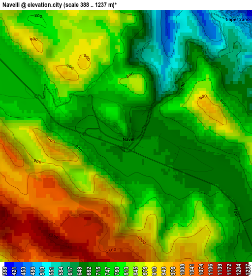
Below is the Elevation map of Navelli, which displays elevation range with different colors. Scale of the first map is from 388 to 1237 m (1273 to 4058 ft) with average elevation of 805.4 meters (=2642 ft) [note 1]
These maps also provides idea of topography and contour of this city, they are displayed at different zoom levels. More info about maps, scale and edge coordinates you can find below images.
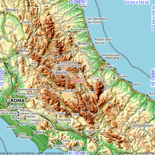
| \ | Map #1 | Topo.Map |
| Scale [m] | 388..1237 m | × |
| Scale [ft] | 1273..4058 ft | × |
| Average | 805.4 m = 2642 ft | × |
| Width | 7.24 km = 4.5 mi | 231.5 km = 143.8 mi |
| Height | 7.24 km = 4.5 mi | 231.5 km = 143.8 mi |
| ↑Max Latitude | 42.269737° | 43.26976° |
| Latitude at center | 42.23721° | 42.23721° |
| ↓Min Latitude | 42.204666° | 41.18749° |
| ← Min Longitude | 13.685665° | 12.32336° |
| Longitude center | 13.72961° | 13.72961° |
| →Max Longitude | 13.773555° | 15.13586° |
Nearby cities:
Cities around Navelli sort by population:
• Bussi sul Tirino elevation 323 m
8.3 km,  108°
108°
• Capestrano 464 m
4.7 km,  42°
42°
• Ofena 491 m
10.1 km,  13°
13°
• Molina Aterno 495 m
9.8 km,  177°
177°
• San Pio delle Camere 763 m
8 km,  310°
310°
• Collepietro 847 m
4.6 km, 113°
• Castelvecchio Calvisio 1038 m
9 km,  337°
337°
• Caporciano 825 m
4.8 km,  287°
287°
• San Benedetto in Perillis 854 m
6.8 km,  150°
150°
• Acciano 594 m
6.8 km,  188°
188°
• Tione degli Abruzzi 588 m
8.6 km,  244°
244°
• Carapelle Calvisio 845 m
7.7 km,  332°
332°
Multilingual:
 En español:
Navelli elevación 711 m.
 En France:
Navelli élévation 711 m.


Sources and notes:
- [note 1] Map square and city borders are not equal. Map elevation data is calculated only from area inside that square.
- [src 1] Elevation data from geonames database provided with same terms of usage.
- [src 2] The elevation map of Navelli is generated using elevation data from NASA's 3 arcsec (90m) resolution SRTM data.
- [src 3] Base (background) map © OpenStreetMap contributors tiles are generated by Geofabrik and OpenTopoMap.
Copyright & License:
This Navelli Elevation Map is licensed under CC BY-SA. You may reuse any part from this page, if you give a proper credit by linking to this URL:
 More info on terms of use page.