Ofena elevation
Ofena (Abruzzo, Provincia dell' Aquila), Italy elevation is 491 meters and Ofena elevation in feet is 1611 ft above sea level [src 1]. Ofena is a seat of a third-order administrative division (feature code) with elevation that is 169 meters (554 ft) bigger than average city elevation in Italy.
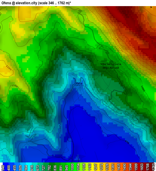
Below is the Elevation map of Ofena, which displays elevation range with different colors. Scale of the first map is from 346 to 1762 m (1135 to 5781 ft) with average elevation of 845.3 meters (=2773 ft) [note 1]
These maps also provides idea of topography and contour of this city, they are displayed at different zoom levels. More info about maps, scale and edge coordinates you can find below images.
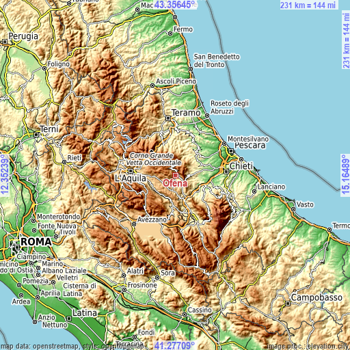
| \ | Map #1 | Topo.Map |
| Scale [m] | 346..1762 m | × |
| Scale [ft] | 1135..5781 ft | × |
| Average | 845.3 m = 2773 ft | × |
| Width | 7.23 km = 4.5 mi | 231.2 km = 143.7 mi |
| Height | 7.23 km = 4.5 mi | 231.2 km = 143.7 mi |
| ↑Max Latitude | 42.357842° | 43.35645° |
| Latitude at center | 42.32536° | 42.32536° |
| ↓Min Latitude | 42.292861° | 41.27709° |
| ← Min Longitude | 13.714695° | 12.35239° |
| Longitude center | 13.75864° | 13.75864° |
| →Max Longitude | 13.802585° | 15.16489° |
Nearby cities:
Cities around Ofena sort by population:
• Capestrano elevation 464 m
6.4 km,  173°
173°
• Castel del Monte 1345 m
5.2 km,  328°
328°
• Navelli 711 m
10.1 km,  193°
193°
• San Pio delle Camere 763 m
9.6 km,  241°
241°
• Villa Celiera 728 m
10.3 km,  52°
52°
• Castelvecchio Calvisio 1038 m
6.1 km,  255°
255°
• Carpineto della Nora 526 m
8.4 km,  83°
83°
• Villa Santa Lucia degli Abruzzi 872 m
1.8 km,  62°
62°
• Calascio 1210 m
5.1 km,  270°
270°
• Santo Stefano di Sessanio 1246 m
9.6 km,  282°
282°
• Brittoli 756 m
8.4 km,  97°
97°
• Carapelle Calvisio 845 m
6.6 km, 243°
Multilingual:
 En español:
Ofena elevación 491 m.
 En France:
Ofena élévation 491 m.


Sources and notes:
- [note 1] Map square and city borders are not equal. Map elevation data is calculated only from area inside that square.
- [src 1] Elevation data from geonames database provided with same terms of usage.
- [src 2] The elevation map of Ofena is generated using elevation data from NASA's 3 arcsec (90m) resolution SRTM data.
- [src 3] Base (background) map © OpenStreetMap contributors tiles are generated by Geofabrik and OpenTopoMap.
Copyright & License:
This Ofena Elevation Map is licensed under CC BY-SA. You may reuse any part from this page, if you give a proper credit by linking to this URL:
 More info on terms of use page.