Ordona elevation
Ordona (Apulia, Provincia di Foggia), Italy elevation is 121 meters and Ordona elevation in feet is 397 ft above sea level [src 1]. Ordona is a seat of a third-order administrative division (feature code) with elevation that is 201 meters (659 ft) smaller than average city elevation in Italy.
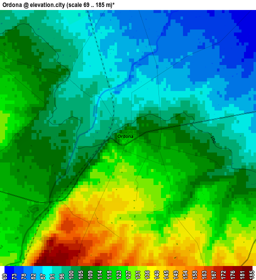
Below is the Elevation map of Ordona, which displays elevation range with different colors. Scale of the first map is from 69 to 185 m (226 to 607 ft) with average elevation of 109.6 meters (=360 ft) [note 1]
These maps also provides idea of topography and contour of this city, they are displayed at different zoom levels. More info about maps, scale and edge coordinates you can find below images.
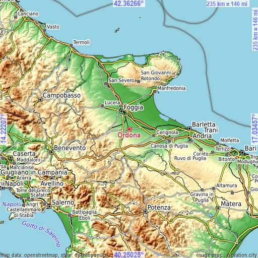
| \ | Map #1 | Topo.Map |
| Scale [m] | 69..185 m | × |
| Scale [ft] | 226..607 ft | × |
| Average | 109.6 m = 360 ft | × |
| Width | 7.34 km = 4.6 mi | 234.9 km = 146 mi |
| Height | 7.34 km = 4.6 mi | 234.9 km = 146 mi |
| ↑Max Latitude | 41.348009° | 42.36266° |
| Latitude at center | 41.31501° | 41.31501° |
| ↓Min Latitude | 41.281995° | 40.25025° |
| ← Min Longitude | 15.584375° | 14.22207° |
| Longitude center | 15.62832° | 15.62832° |
| →Max Longitude | 15.672265° | 17.03457° |
Nearby cities:
Cities around Ordona sort by population:
• Foggia elevation 72 m
17.2 km,  338°
338°
• Cerignola 126 m
23 km,  103°
103°
• Orta Nova 69 m
7 km,  77°
77°
• Troia 384 m
26.5 km,  281°
281°
• Carapelle 61 m
7.7 km,  45°
45°
• Ascoli Satriano 418 m
13.4 km,  202°
202°
• Stornara 108 m
12.2 km, 104°
• Stornarella 153 m
10.8 km,  127°
127°
• Deliceto 600 m
22.8 km,  243°
243°
• Bovino 601 m
25.2 km,  253°
253°
• Candela 473 m
22 km,  205°
205°
• Castelluccio dei Sauri 280 m
12.8 km,  264°
264°
Multilingual:
 En español:
Ordona elevación 121 m.
 En France:
Ordona élévation 121 m.


Sources and notes:
- [note 1] Map square and city borders are not equal. Map elevation data is calculated only from area inside that square.
- [src 1] Elevation data from geonames database provided with same terms of usage.
- [src 2] The elevation map of Ordona is generated using elevation data from NASA's 3 arcsec (90m) resolution SRTM data.
- [src 3] Base (background) map © OpenStreetMap contributors tiles are generated by Geofabrik and OpenTopoMap.
Copyright & License:
This Ordona Elevation Map is licensed under CC BY-SA. You may reuse any part from this page, if you give a proper credit by linking to this URL:
 More info on terms of use page.