Candela elevation
Candela (Apulia, Provincia di Foggia), Italy elevation is 473 meters and Candela elevation in feet is 1552 ft above sea level [src 1]. Candela is a seat of a third-order administrative division (feature code) with elevation that is 151 meters (495 ft) bigger than average city elevation in Italy.
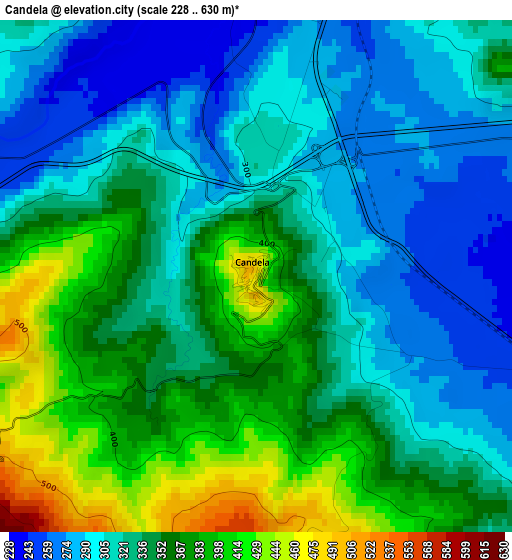
Below is the Elevation map of Candela, which displays elevation range with different colors. Scale of the first map is from 228 to 630 m (748 to 2067 ft) with average elevation of 337.8 meters (=1108 ft) [note 1]
These maps also provides idea of topography and contour of this city, they are displayed at different zoom levels. More info about maps, scale and edge coordinates you can find below images.
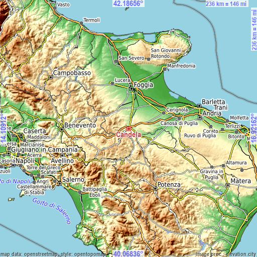
| \ | Map #1 | Topo.Map |
| Scale [m] | 228..630 m | × |
| Scale [ft] | 748..2067 ft | × |
| Average | 337.8 m = 1108 ft | × |
| Width | 7.36 km = 4.6 mi | 235.5 km = 146.3 mi |
| Height | 7.36 km = 4.6 mi | 235.5 km = 146.3 mi |
| ↑Max Latitude | 41.169099° | 42.18656° |
| Latitude at center | 41.13601° | 41.13601° |
| ↓Min Latitude | 41.102904° | 40.06836° |
| ← Min Longitude | 15.471425° | 14.10912° |
| Longitude center | 15.51537° | 15.51537° |
| →Max Longitude | 15.559315° | 16.92162° |
Nearby cities:
Cities around Candela sort by population:
• Ascoli Satriano elevation 418 m
8.7 km,  29°
29°
• Deliceto 600 m
14.6 km,  311°
311°
• Zona 179 527 m
17.1 km,  149°
149°
• Accadia 652 m
15.6 km,  278°
278°
• Castelluccio dei Sauri 280 m
19 km,  349°
349°
• Rocchetta Sant'Antonio 612 m
5.9 km,  231°
231°
• Lacedonia 728 m
12.4 km,  219°
219°
• Sant'Agata di Puglia 759 m
11.5 km, 278°
• Aquilonia 754 m
16.9 km,  191°
191°
• Scampitella 781 m
18.7 km,  254°
254°
• Bisaccia 898 m
18.3 km, 219°
• Monteverde 712 m
15.4 km,  174°
174°
Multilingual:
 En español:
Candela elevación 473 m.
 En France:
Candela élévation 473 m.


Sources and notes:
- [note 1] Map square and city borders are not equal. Map elevation data is calculated only from area inside that square.
- [src 1] Elevation data from geonames database provided with same terms of usage.
- [src 2] The elevation map of Candela is generated using elevation data from NASA's 3 arcsec (90m) resolution SRTM data.
- [src 3] Base (background) map © OpenStreetMap contributors tiles are generated by Geofabrik and OpenTopoMap.
Copyright & License:
This Candela Elevation Map is licensed under CC BY-SA. You may reuse any part from this page, if you give a proper credit by linking to this URL:
 More info on terms of use page.